
The Mysteries of Easter Island
In the middle of the Pacific Ocean sits one of the most enigmatic places in the world (and one of the most remote!).

When I planned my first trip to South America, the primary goal was finding the very big cats of Chile and Brasil - but the former is also home to a rather surprising place, so different from the rest of the country that many people don’t know of its national belonging: Rapa Nui - or commonly known as the Easter Island. In the middle of the Pacific Ocean sits one of the most enigmatic places in the world (and one of the most remote). Although time was a little short and I ended up being able to spend just 2 days here, I couldn’t miss the opportunity.
Getting there…
…was half the battle. Or a little more than half. While Chile is already not the most centrally located and easily accessible country (admittedly that depends on where you start from), the Easter Island is on another level: Considered one of the most remote inhabited places in the world, it’s part of the Polynesian Triangle in Oceania. Its closest inhabited neighbor are the Pitcairn Islands (population: 40) at over 2000km away, while mainland Chile itself is 3500 km to the east. That’s a good 6h flight - of which there is one per day at the time of my travels in August 2024.

A Bumpy Ride
I was thinking about these facts as we made our third landing attempt, having aborted two due to very heavy winds, and circling for almost an hour over literal no-mans-land while we hoped for the storm to clear.
The pilots finally managed to land on the surprisingly long runway, which is one of the first peculiar things about this place: the island was originally considered as an abort site for Space Shuttle missions, and NASA extended the runway in the late 1980s. Nowadays that means a Boeing 787 can land on what is considered the most remote airport in the world, in a place with a population of less than 10,000 people.


The weather during my two days was a very mixed bag, as is common in this part of the world. The sea was rough, and the cloud cover only lightened for a few hours each day, and sadly less so (that is to say, not at all) during the night, which would turn out to be one of the disappointing aspects of this journey. More on that later.
Hanga Roa
As the rain cleared, I started with a short walk through the primary (and only) settlement on the island. Hanga Roa sits on the western side right next to the runway, and is home to the vast majority of the population, its only hospital, a football pitch, harbour, and quite a few restaurants, small hotels, and guest houses - tourism is a primary economic activity, supplemented by some farming and fishing, as well as the administrative aspects and a presence of the Chilean military.


A first Glimpse
Without meaning any disrespect, the city isn’t the reason to make the trip to the island for most visitors. But it does give you a glimpse of why most tourists arrive here: Just opposite the football pitch, you will find one of the almost 900 moais on the island.
This is probably the first encounter any tourist will have with them. Their story is long, controversial, full of unanswered questions, and of course adds to the mystique of the place…

As you walk just a few hundred meters further along the coast, a whole set of them awaits, situated on the typical “Ahu” giving many of the sites their names: a stone pedestal that serves as the altar for the moai placed on them. Despite its fame, the site only gets a little busy during sunset, otherwise you’ll find mostly stray dogs and horses around…

The Boat House - Hare Paenga
Close to the site is also a remnant of what the ancient accommodation looked here on the island: the so-called boat house, referring to the resemblence the finished houses have to a boat turned upside-down on land. Nowadays only the elliptical shape of the stone foundation is left.


I would visit these moais a few more times for some photos, as it was just a 20 minute walk from my hotel. The island is not very big - about 10 by 20 km in a triangle shape.
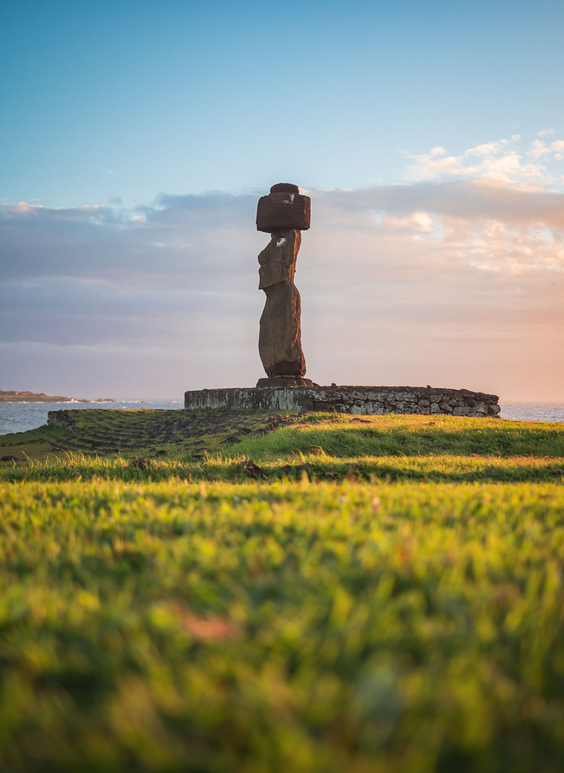
The collection here include this one called Ahu Ko Te Riku, which features the traditional hat like structure called Pukao, made from volcanic rock and added to the statues at a later stage, as well as the eyes made from coral stone, placed into the sockets and adorned with black obsidian or red scoria serving as pupils. This specific moai is the only completely restored one on the island with these features.

So many Questions?
It is at this stage (if not before) that you ask yourself what the point of these huge statues is, how they were made and moved to their resting places, and by whom and when! Some of those questions we shall try to answer in this blog…

The Moai
Although many of these questions have not been conclusively answered, there is plenty of evidence around. One such piece of evidence tells the tale of where the statues were produced: The quarry at Rano Raraku.


Almost all of the moai on the island were born on this site in the northern part of the islands, situated on the slope of an extinct volcano. The unfinished remnants of about 400 of them can still be found here, sometimes toppled over, partly buried, half finished in the rock, or simply abandoned during transport.

All the status are monolithic, and on average about 4 meters tall, weighing in excess of 10 tons. Some of them however are much bigger - the tallest standing at around 10 meters. Take a look at the above images to see how they scale against humans and horses.
The largest incomplete one seen here however is called Te Tokanga (the Giant), would be more than 20 meters tall, and weigh at least 270 tons, a multiple of the typical status scattered around the island.


It is often assumed that the moai are only “heads”, but in fact they represent full bodies - their heads are just oversized and the statues do not have very distinct legs. Some of them are in fact buried in the ground, with only the top third or so sticking out. Many moai feature carved designs, primarily on the back, and some of them were painted as well.

The quarry was active for several hundred years - it is said that most of the moai were built between 1100 and 1600 CE, with the peak somewhere in the middle of that period. The exact dates vary depending on the source. Moai carving was abandoned quite suddenly towards the end of this period, associated with the end of the Rapa Nui society that built them. The reasons for this remain controversial and unclear, ranging from the impact of contact with European explorers throughout the 18th century, to the disputed ecocide theory of self-induced collapse owing to resource imbalances.

Their Makers
But who made up this society? And did they have cats? These were the critical questions.
(Well, maybe the latter one was not so important, and cats only arrived at the island much later, but again showing why they are the truly dominant species of the globe).
The people erecting the moai were of Polynesian descent, arriving to the islands in ocean-going canoes after what must have been an incredible feat of navigation and endurance. When this happened seems difficult to say, and estimates range from around 400 to 1100 CE - even reliable sources do not fully agree on the dates, but the MET says it happened around 600 - 800 CE.
Ahu Tongariki
As you look east from the quarry, you will see their most famous work: a row of 15 moai standing on a huge stone platform, all facing inland, away from the sea. It is said that the reason for this placement is to watch over the villages and communities inland. The moai are considered to be representations of the Polynesians' ancestors, carrying their spiritual essence called “mana”.


As you get closer to the site, you can once again appreciate their size - the base plate alone is almost as tall as a human. Ahu Tongariki was the capital of one of the Rapa Nui clans on the eastern end of the island. Its claim to fame comes not just from its row of moai, but also the so-called “Traveling Moai” in front of it, for two reasons: it was shipped to Japan (and back) for an expo in Osaka in 1982, and later became the testbed for Thor Heyerdah, one of the most prominent researchers working on understanding Rapa Nui culture, who wanted to investigate how the moai were transported. Indeed, they made him “walk” for a few meters using ropes to generate a swinging motion. Whether this was truly the way they were transported for many kilometers remains disputed and alternative hypotheses add a kind of sled or cantilevers to move them along the ancient roads.


Celestial alignment
The site is positioned to provide perfect perpendicular alignment with our home star on the summer solstice around December 21st each year - for my vist in August, I needed a different perspective to get sun in frame (I visited both during sunrise and sunset). Sunrise here is also one of the few times where things get a little busy for an hour or two.


Toppled
Close the 15 main moai here lies a toppled one, with its facial structure somehow resembling the volcanic cliffs of Rano Raraku just behind. In fact, all the moai on the island were toppled over around the 17th and 18th century. Reasons are thought to be intertribal warfare to loss of faith in the ancestors' ability to protect them as Europeans arrived.

Restoration
As a result, all 50 or so standing moai (except some of the ones buried at the quarry) have actually been restored, mostly in the early second half of the 20th century. Ahu Tongariki suffered twice though - a tsunami toppled them over again in 1960 and swept the moai inland.
It was only in the 1990s that a team of Chilean and Japanese archaeologists restored them to their current state. The (few) photos floating around from the restoration efforts, one of them placed on a stone inscription at the site, feel quite surreal.

Luckily these 15 are now back on their (not-so-prominent) feet, including one with the red-colored Pukao top heat. These alone can weigh up to 10 tons, and it is believed a kind of ramp system helped the Rapa Nui to raise and balance them on the statues.

Ahu Tongariki from the sea, with the steep rim of the Rano Raraku caldera in the background. The quarry lies to the left side of the slope.
Beyond the Moai
We move on from our stone-headed friends for the moment, as there are a few other culturally interesting sites and beautiful landscapes to explore here. One of the former attractions is the so called Naval of the World - a rather peculiar stone structure on the northern coast of the island.

Natives
To get there, you need to make it past this man - an elderly Rapa Nui, a descendant of the indigenous Polynesians, which make up a bit more than half of the islands population today, with more having settled on mainland Chile after the island was annexed in the late 19th century.

Once the first guard is cleared, you need to bribe the second one with some cuddles - luckily my guide Yoyo has built some credit over the years.

Feline Tour
Indeed, it seems we qualified for dedicated guidance to find the Naval of the World!
As we look for it, we passed the remains of the tallest moai ever erected on the island at around 10 meters, with its Pukao on the left - almost 2m in height by itself.


The site is quite simple: the primary attraction is this central round stone, which is said to have been brought to the island specifically by the first king, Hotu Matua. One of its peculiar qualities is the impact it has on any compass in its vicinity, most probably due to its mineral content, although of course others may argue it’s the ephemeral spiritual power emitted from this piece of rock, the aforementioned “mana”.

Pu o Hiro
Just a little further down the road, a small unremarkable area with a simple fenced area is home to another rather interesting stone: this one posses some musical capabilities, and the locals would blow into one of the holes to create a trumpeting sound that served several purposes. A primary one was a call to aid fertility, and indeed, the stone features a few carvings that represent the female reproductive parts… other benefits seem to have been a trigger for rain, and for the fish to come closer to the coast.
The stone was actually on the move regularly during its original use, and its magic powers aided those victorious in clan battles.

A drive along one of the roads cutting across the islands brings you past one of its mounts, the small extinct volcano called Maunga Pu’i, with its beautiful textures and an almost fluffy looking covering of various bushes and grasses, with bright very green centre.

This place is home to a crazy yearly extreme sport event, where locals in traditional outfits use a kind of wooden sled to descend its slope from the rim in just a few seconds and dizzying speeds, with sometimes less than ideal outcomes. I did not get to observe this, but if you happen to be on the island whenever it takes place (dates seem to be around February during the Tapati festival, but it changes) don’t miss it.
Even if you tried, it’s hard to escape the ever present moai sites. They are spread all over the island, and although only a few feature standing statues, there are also a number of empty platforms (Ahu), and several toppled remnants dotted in the landscape.

Ahu Akivi
One more beautiful sight with several standing ones is the seven moai of Ahu Akivi, facing the sunset during the spring equinox and the only site not on the coast.

Ahu Nau Nau
Another is the beachfront collection at Ahu Nau Nau, where four moai still feature their characteristic hats.


The Moai under the Stars?
One of my goals for this trip was to try and capture the Milky Way rising above the moai. I liked the idea of connecting the mystery of their existence with the unknowns of our night sky. Unfortunately, the clouds had other plans. Despite two late-night outings (each after a long, exhausting day) I only got about ten minutes of clear skies through a small break in the clouds, leaving very little time to set up a proper composition.


It was not easy to arrange for access to the sites away from city lights at night (as they are in the National Park), get a guide to take me there at midnight, and skip pretty much all sleep for 3 days, only to then walk away with very little result after all the effort. I can’t deny that on my departure a certain frustration took over - that has settled a little by now, and turned into a motivation to go back and plan a few more nights on the island…

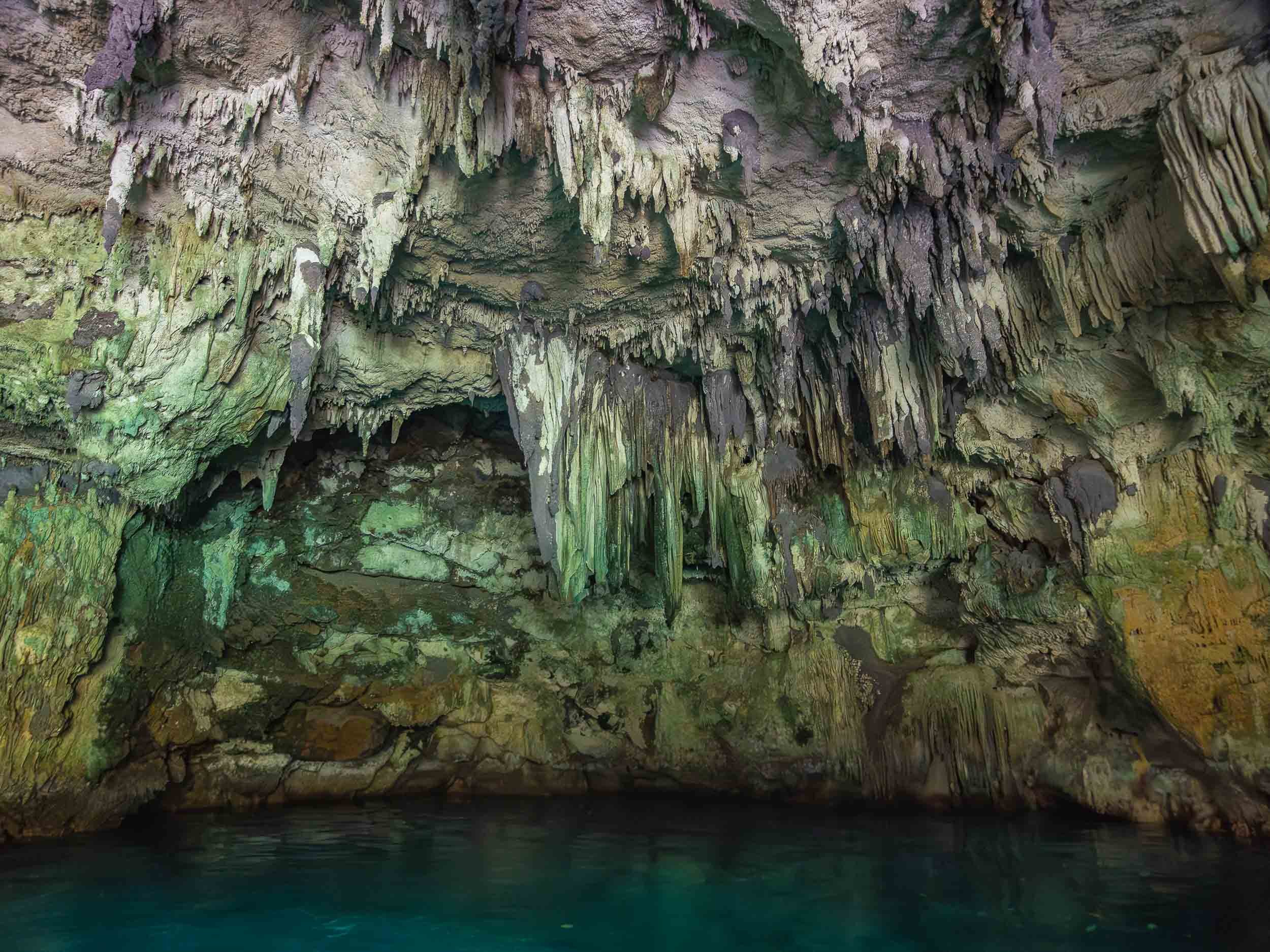
Rano Kau
On the south western tip of the island lies its largest volcanic crater. The southern edge of the caldera features a small dip where the lava once made its way into the ocean, the slope eroded by wind and waves into 300m tall cliffs.


The site is quite easy to reach, and part of the crater’s edge can be traversed on foot, allowing for views into the beautiful lagoon at the centre of the volcano. There are no permanent freshwater sources on the island, so the various volcanoes’ rainwater lakes played a central role in the past.

Rainwater Collection
It is also for this reason that in some locations around the island you can find these ancient stone bowls, which were used to gather freshwater at the time.
Orongo & the Birdman Cult
Just a bit further from the crater viewpoint lies the ceremonial village of Orongo. While the island’s culture is most well-known for the moai - rightly so probably - this aspect of the local rituals is less famous but rather intense. The cult emerged as the intrigue of the moai and their relevance as ancestral holdouts of hereditary power faded in the late 17th century, triggering a need to establish new patterns of power acquisition among the island's tribes, in the honor of the creator god Make Make.
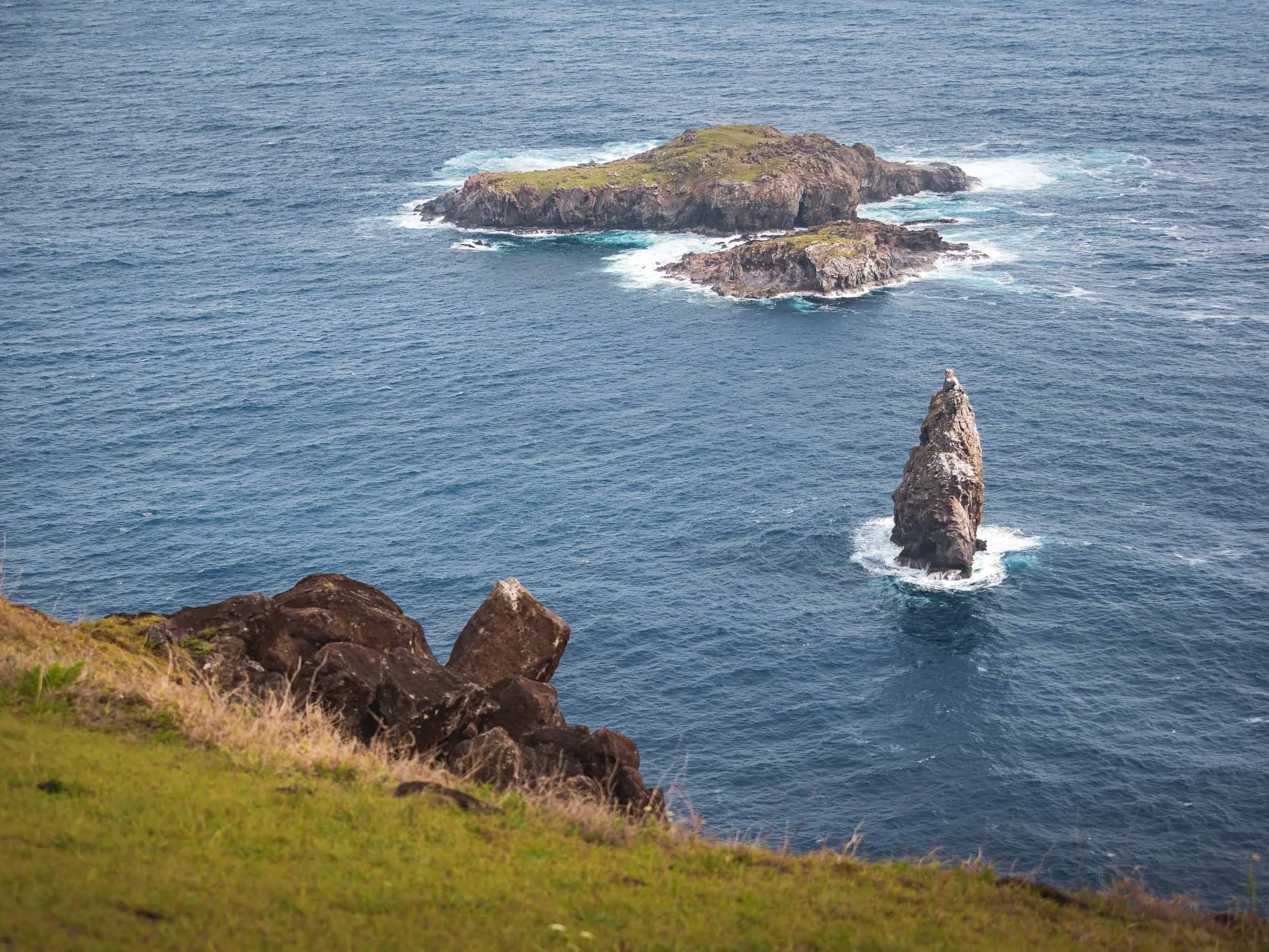
Naturally, someone came up with the idea to satisfy this need by making contestants climb down the vertical cliffs at the edge of the island, brace the waves and sharks to swim to the furthest of the nearby islands, and wait for weeks for the arrival of the manutara bird, in order to collect its first eggs.
Then the warrior could announce his (yes, only men participated) success, but still had to make the way back with the intact egg to cement his clans rise to the top of the governance system for the following year, while he himself would spend most of it in a ritual confinement with very little to celebrate. Logical!
Having said that, the prominence of birds in the beliefs of the local is probably not surprising given that there were few other mammals or reptiles on the island. The islets to the south of Orongo can be seen here in the distance, the furthest of which the contestants had to reach to retrieve the highly sought after bird egg.


The village consists of 54 stone houses, the remnants of some are visible here to the left and right, including one of the entrances. It was only occupied during the spring time for the ceremony.

Dozens of large petroglyphs can be found here as well, many representing the Birdman cult.

Another example of these kind of petroglyph carvings is visible at the small outdoor museum on the road to the crater - you can see the bird-like drawings if you look closely.

Although often overlooked, there are actually beautiful petroglyphs at Ahu Tongariki as well, just a few dozen meters from the statues. Some of them also relating to the Birdman culture, while others show the face of the Make Make creator god and other important aspects of the Rapa Nui culture - even an image of a tuna (food is important)!


Religion
I spent my last morning with a final walk through Hanga Roa before my departure. The only Catholic church on Easter Island is one of the most prominent evidences of religious syncretism here - it features a mix of traditional mythology from the island, mixed with Christian symbolism. Even an effigy of Make-Make makes an appearance inside, and some of the mass proceedings mix both of the cultures.

The nearby cemetery includes graves that mix both spiritual approaches as well - I didn’t take more photos here out of respect, but there are graves with moai replicas, and some shaped like traditional canoes. Nevertheless, the arrival of Christian missionaries in the second half of the 19th century had a key influence on the diminishing role of the Rapa Nui culture.

Outside Impact
Aside from the religious influence, the arrival of Europeans unsurprisingly had a lot of other consequences for the island - starting with its name, given to it by the Dutch explorer Jacob Roggeveen, who was the first to set foot on the island in 1776 on Easter Sunday.
Spanish and British explorers arrived later, but the first serious negative consequences manifested themselves when Peruvian smugglers took over 1000 Rapa Nui as slaves, only to later return some of them diseases that wiped out a lot of the population. This continued when a French businessmen wanted to take over the island and use it as a sheep farm, forcing the local population to give up their land - in the end, only over 100 or so Rapa Nui were left in 1877.

Chilean Influence
Not long after this period, Chile moved to annex Rapa Nui, reportedly using misleading translations to secure agreement from the local population. This marked the beginning of a long phase of exploitation, during which the Rapa Nui were denied basic rights and restricted to living in the town of Hanga Roa. It wasn’t until 1966 that they were finally granted Chilean citizenship. Today, the island benefits from certain administrative privileges, and the designation of the Rapa Nui National Park as a UNESCO World Heritage Site in 1995 brought greater international attention and access to resources. Despite this progress, tensions still exist between the islanders’ desire for self-determination and the interests of the Chilean state - and indeed other countries: for example, one of the most famous moai called Hoa Hakananai'a with beautiful petroglyphs was taken from the island in 1886 and now sits in the British Museum, but there are regular voices for it to be returned to the island (sounds familiar?).
And that’s the end of my short time on the island - too short. Really keen to go back, explore more of the ancient volcanoes, a few more interesting natural and cultural sites, and most of all, get the chance to take some proper Milky Way photos with the moai 🗿✨ … one day!

A small notes on drone flying: I only flew mine twice, reasons being partly weather and wind, but primarily that most of the island is part of the Rapa Nui National Park, where flying is not allowed. I relied on my guide to decide when and where it would be ok to fly.
Subscribe to my newsletter to get notified and don’t miss out on more Wonders of the Globe.
Other Recent Posts:


Pacific Island Wonders - Palau
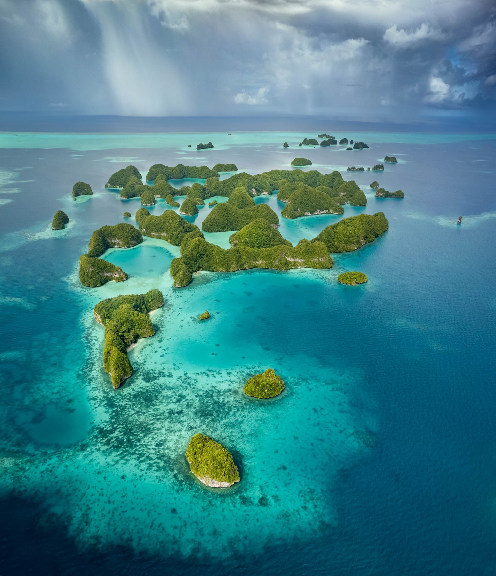
Prepare to see some of the most intense blue and green colours your eyes have ever feasted on in this post! The unknown Republic of Palau in the Pacific about 700km eastwards from the coast of the Philippines is truly home to some of the most beautiful island formations I’ve ever seen…
Prepare to see some of the most intense blue and green colours your eyes have ever feasted on in this post! The unknown Republic of Palau in the Pacific about 700km eastwards from the coast of the Philippines is truly home to some of the most beautiful island formations I’ve ever seen, but it also has an interesting colonial history and a few obscure sights - read on!
Start here - a short clip of some of the most beautiful locations of the Rock Islands in the southern lagoon of the country , starting with the nature reserve of Ngerukewid… more on that below!
What I came for
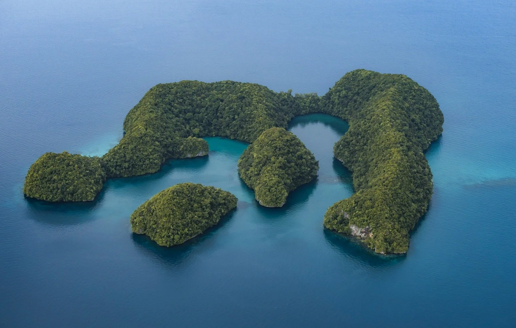
My hero shot, and what I wanted to document during this trip: The incredible islands of Ngerukewid are definitely one of the most beautiful island formations I’ve ever seen and have been declared a nature reserve as far back as 1956, owing to their amazing biodiversity.


15min after the shot!
Getting this photo was one of the main reasons I visited the tiny hardly known island nation in the Pacific, and making it happen proved to be challenging: Difficult and fluctuating weather conditions, having to charter a boat, getting close enough to the reserve boundaries, flying my drone in strong winds and waves, and landing it on the boat‘s sunroof. Of course, I had to get a drone permit as well.
The rain clouds you see in the distance in the final result caught up on us shortly after, and the captain and myself looked for shelter of the waves and rain on a small nearby beach.
The southern lagoon is full of amazing places, often best seen from the air. Virtually unpopulated, the whole 42 sqkm site was declared a UNESCO World Heritage Site in 2012.


The islands are largely made from coral and limestone, often in beautiful mushroom like formations due to tidal erosion, which also caused this arch.

Goomba Island?
Does anyone else feel like this is straight out of Super Mario? Look at “Goomba” if you don’t believe me…
Underwater Wonders
Of course, an ocean paradise like this offers a whole different view when looking underwater - which admittedly wasn’t such a big focus for me on this trip (I have yet to do my PADI, but on the other hand I finally got an underwater camera case - these photos are shot on iPhone though). Nevertheless, some snorkeling is always on the cards.
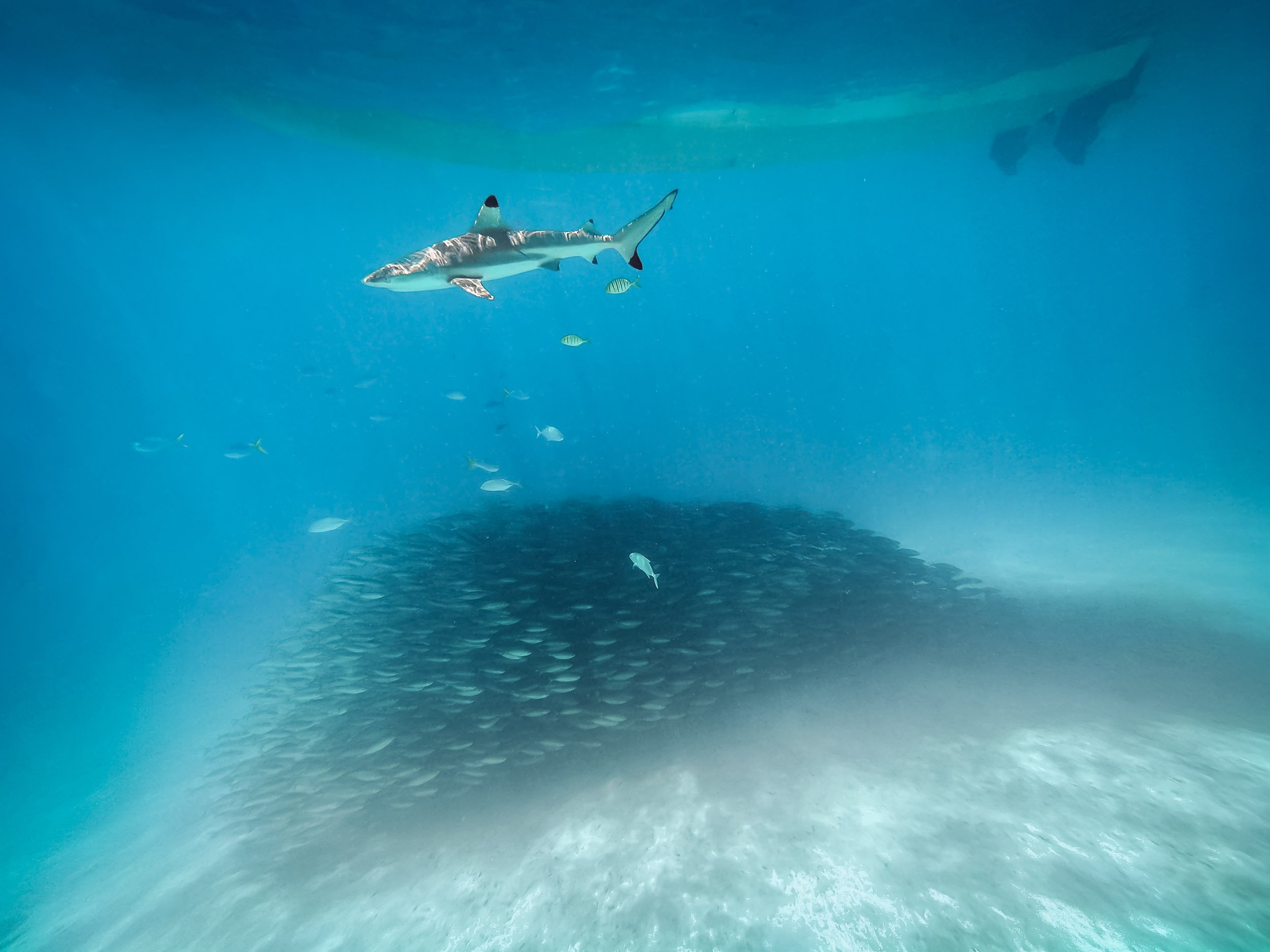
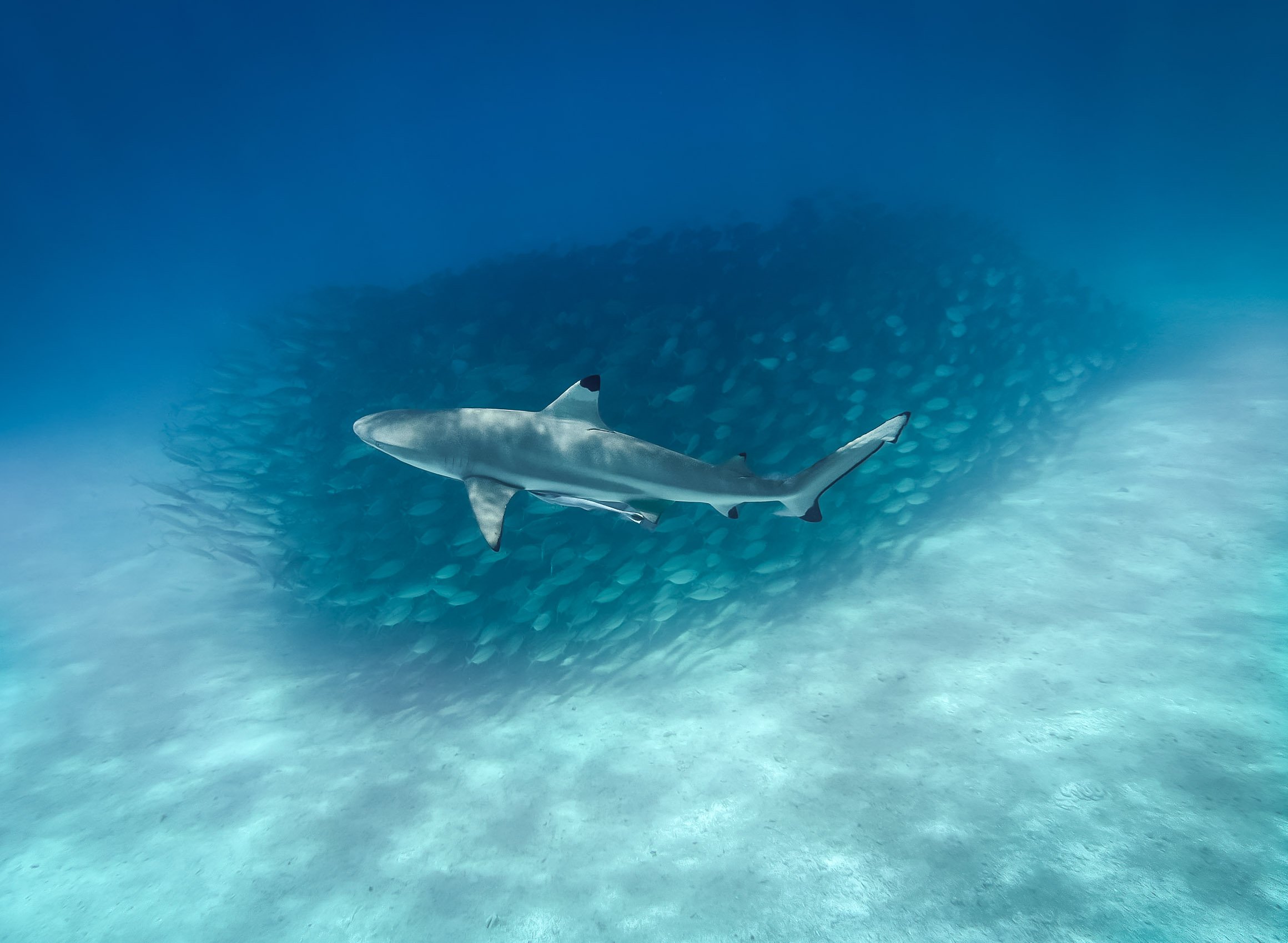
Blacktip reef sharks frequent some of the beach areas in the rock lagoon, allowing you to swim among them. A school of fish found some shelter below our boat, letting me capture these photos.


Palau is also famous for its many marine lakes such as this one - the most well known one is 12,000 year old aptly named Jellyfish lake. It’s home to millions of Jellyfish, specifically the stingless golden and moon jellyfish species - or so it has been for the last years. Unfortunately, the population of golden jellyfish died out almost completely in late 2022, likely due to a rise in water temperatures. This had happened before and they luckily recovered within a few years, but no one knows if this will be the case again.
As a result, snorkeling in the lake was a lot less exciting that it might have been, but I did get to see a few beautiful moon jellyfish individuals, pictured above.

Remnants
Palau’s underwater world is also home to a lot of man-made attractions, albeit unintentional ones. The country was home to fierce battles during the Second World War - this is the coral covered fuselage of a Japanese war plane. The cockpit wasn’t far either.
Lunch spot
This wreck was just a few meters from a small beach where we had our lunch that day - with the backdrop of this beautiful tree slowly shedding some of its orange leaves, creating a beautiful kaleidoscope of colours.


More evidence of the fierce battles that took place here in form of a sunken transport ship, and cannons that were abandoned in small limestone caves on the lagoon entrances. The largest battle that took place here was the US - Japan encounters on Peleliu, which reshaped the geography of the island significantly.

White Rock Lily
The national flower of the country and one of the many endemic plants that occur here.
Back on Land
Palau does have more to offer than its oceanic beauty - the country consists of over 300 islands, while its population of less than 20,000 (!) lives spread out on just a few of them. Koror is the largest city and used to be the capital until 2006, when it was replaced by Ngerulmud on the largest island of Babeldaob in a somewhat odd government plan - more on that below.

Koror–Babeldaob Bridge
The bridge linking Kotor with the main island of the country, built in 2002 with Japanse aid after the previous bridge collapsed unexpectedly 1996.
While the last few hundred years of the country have been shaped by Spanish, German, Japanese, and then US colonialism and influences, traces of the native population go back much further than that, and some of it is preserved around the main island of Babeldaob. The most significant evidence dates back over 2000 years ago in form of the Stone Monoliths of Ngarchelong, a collection of stones in the north of the island, not far from the shoreline.

Basalt Monoliths
The stones have been dubbed the “Easter Island of Micronesia” - although I suspect the original is a little more impressive. Their use has not conclusively ascertained, but one theory is that they served as the base for a very large Bai, the traditional meeting house for the locals. Some of the stones have distinctly anthropomorphic shapes, suggesting a different purpose.


A hidden Stone Coffin
The stone coffin of Tet el Bad is located in the village of Ollei - it is on the tentative list as a UNESCO site, but there is literally no information about it available anywhere that I could find - I could barely find the coffin itself. A deserved addition to the list of oddities I discovered during my travels.

Local Traditions
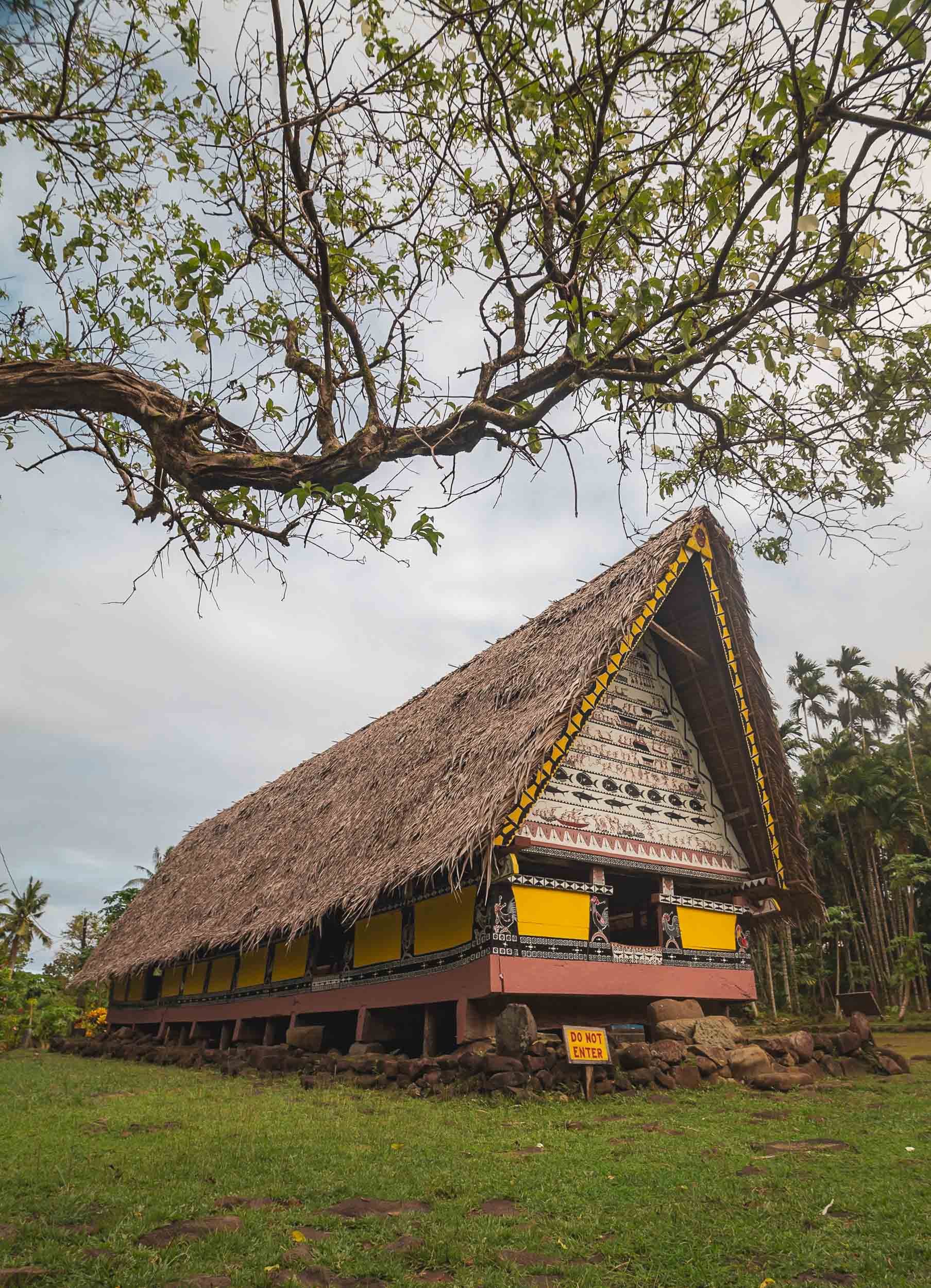
Until today, some local traditions remain active, such as the building of the traditional canoe like war boats. One can be found near Airai, where it is maintained for festivals and races, although it is a dying art today. Luckily even the most obscure topics are often documented nowadays, such as in this paper describing the building process in great detail.


Airai is also home to the oldest Bai ai in Palau, which is still maintained and in use by the local villages, seen on the left here. The right one is located at (interesting) Belau National Museum (Belau is the historic name of the country). Although the Bai is a meeting place for men, Palau’s culture is highly dominated by matrilineal tendencies, evident in practices such as inheritance.

Although there remains a traditional government structure that still influences the country's affairs through its federation of clans, Palau today has a federal government structure that takes the form of a democratic republic. It’s an independent country, but still holds close ties to the US, which provides funding and military support in exchange for its own military rights. The US dollar is the country’s currency and English is widely spoken, although there are still Palauan and other official traditional languages, even Japanese remains an official language in one of the districts.


On the way to Airai lies this abandoned World War II Japanese Communications Center. While there’s a small signboard outside (and an entrance fee to be paid), it is more suitable for an abandoned places exploration than a tourist attraction, offering a few cannons and not much in terms of narrative, but a good chance of getting buried under a crumbling ceiling.
Capital Strangeness
While Koror is the commercial centre (and deserves to be called a city), Palau’s capital Ngerulmud is anything but that - in fact, it is the least-populous capital city of a sovereign nation in the world. Arguably, not one person actually lives in the city boundaries, although the surrounding state is home to a total of just over 300 people. It was created on the basis of the constitution established in 1979, which called for a capital to be established on the main island to avoid concentration of power in Koror. That took way longer than outlined in the constitution, and finally was completed in 2006 at a cost of $45m, through the help of a $20m loan by the Taiwanese government. Brace yourself for what these funds were used for, keeping in mind that the whole country has a population of less than 20,000…

National Capital
Inspired by the Washington Capital building, this complex houses all three pillars of the democratic process.
The parliament is called Olbiil Era Kelulau, which means “House of Whispered Decisions.” It derives from the aforementioned Bais, where the traditional chiefs met to discuss critical topics. During those meetings, no communication that is louder than a whisper is permitted, instead quiet messages are used to negotiate on important topics. Smart approach, although I don’t know if congress functions the same.


The building is in fact not made of massive stone and concrete - it’s publicly accessible and you can walk around in many of the buildings, where I noticed a lot of hollow walls and pillars. It’s also not really suitable for the local tropical climate, mould and ventilation issues have been plaguing it since opening.

More Aerial Glory
I was determined to get more aerial views of the Rock Islands, and have been holding out to get on a plane due to the ever-changing weather conditions. Towards the end of my stay, I took the plunge to fly on a small Cessna with an open door (there are no operating civilian helicopters in the whole of Palau) to get some angles that a drone won’t allow.


Palau’s environmental governance is extremely strong, it created the world’s first shark sanctuary, and makes visitors sign a “pledge” into the passport stamp upon arrival, vowing to protect the environment during their time in the country. It shows - the beaches and rock island areas are one of the least polluted ocean patches I’ve ever seen. Some top down photos from my flight, showcasing the incredible green and blue hues that make up most of the landscape in the country.

A different kind of galaxy
The turquoise waters above show another one of Palau’s attractions: the so-called Milky Way lagoon. It’s a shallow lagoon where limestone mud has settled on the ground, which can be retrieved with a small dive. The locals use this paste for skincare.


German Channel
This artificial channel was dug while Palau was under German administration in the early 20th century to ease access into the lagoon. Today it’s a popular dive site.

Shapes
A reef lagoon in the shape of a ray.

Reality?
Some of the formations look like they have been artificially rendered, but I assure you this is a barley edited real photo.
More images of the underwater world, taken on iPhone while snorkeling among some of the reefs in the rock lagoon during a kayak trip.


One of the many limestone caves that get carved into the rock formations.
Also came across this incredibly tiny jellyfish, the species of which I cannot determine, with an even tinier fish companion.


