Climbing Kilimanjaro: Africa’s Tallest Mountain

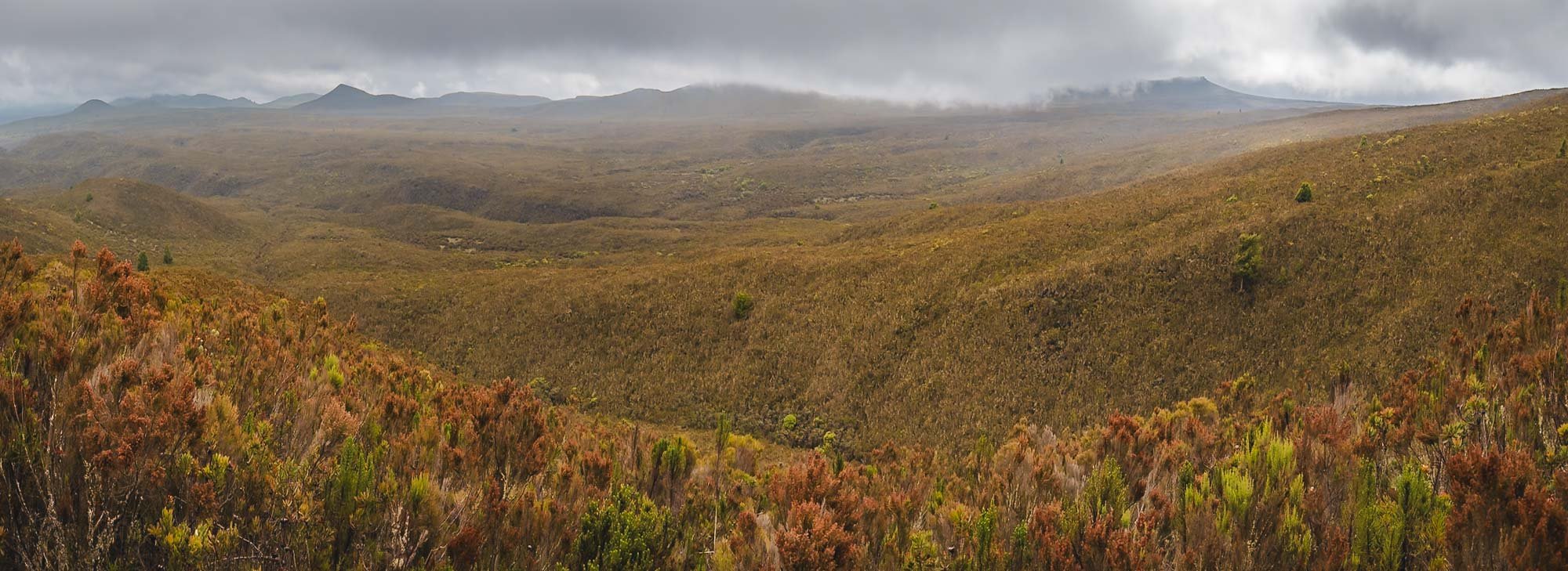
Above the Clouds
Kilimanjaro seen during a balloon flight in Amboseli, Kenya
During my previous visits to Tanzania and Kenya, I’ve come pretty close to one of the continent’s most imposing landmarks: Mount Kilimanjaro. Although I’ve never considered myself a hiker, I did see the appeal of the challenge, particularly as Kilimanjaro is considered quite a safe and manageable climb. No difficult technical parts aside from a bit of scrambling, and longer routes with slow ascent, allowing for gentle acclimatization - you still need to make it up to almost 6000m though.
In addition, Kilimanjaro’s unique snow-capped peak topped with a number of (quickly receding) glaciers, the various ecosystems as you make your way up, and its title as the world’s tallest free-standing mountain, make the challenge even more appealing. Plus, I was sure I’d find some interesting photographic opportunities up there.
In late 2024, an opportunity presented itself: I was given the chance to visit Amboseli National Park in the southeast of Kenya again, documenting its amazing elephants and the conservation work of IFAW (more on that coming soon - subscribe!). The trip would take place at the end of May 2025 and bring me close to the border with Tanzania, making it an easy hop to the foot of the mountain. June is also the time when climbing Kilimanjaro becomes feasible again after the rainy months. It was time to make this happen!
Choices
When planning a Kilimanjaro summit, you have a few choices to make before you even start: What time of the year, what time of the month, and what route? The first two questions are not too difficult: Avoid the rainy seasons (although escaping the wetness completely might be impossible), and consider picking a period where you will summit around full moon-ish - the extra light makes it just a little easier to start the summit push at midnight.

The Lemosho Route
Deciding which route to take can be a bit more tricky - there are a few trade offs (discussed extensively online) between difficulty, scenery, crowds, acclimatization, and duration.
All of them take anywhere from 5-9 days and 50-80km total distance - longer in this case is sometimes better, as you will have more time to acclimatize.
From my research, discussions, and now experience, the route you take is ultimately not so decisive, and almost all of them merge closer to the summit anyway.
I picked the Lemosho route because it covers beautiful forests and the large western plateau, is quite long with gentle altitude gains, and is not the most crowded but neither the most remote. Its ascent path is also quite different from the descent, adding another layer of interest.
I’m happy with my choice - if I were to climb again, I’d consider one of the northern routes as they follow a different summit path, and are generally a little less used.
The base for all Kilimanjaro routes is Moshi, a small-ish but decent town that has everything you need for a some days before and after the trek, and is reachable within a couple of hours from the Kenyan border or from Kilimanjaro airport. Arusha airport is also not too far. The town also has plenty of places to rent equipment - depending on your mountaineering aspirations, I’d say don’t bother buying too many things and making your luggage heavier than you need to. Instead, down-jacket, sleeping bag, gaiters, walking sticks, and thick jacket and pants are things you can consider renting instead. There are plenty of packing lists available online, and they all say more or less the same thing, and I have not much more to add to them from my experience - importantly, consider taking around 40,000 mAh of extra battery capacity if you want to charge phone (Airplane mode), camera, AirPods and flashlight throughout the trip. A solar pack (which I didn’t take) can help.

I opted for a solo-trek - as in, no other hikers with me, but of course you still have a crew - and met Paul, my guide, for a short briefing the day before. We agreed an early morning pickup time, and would stop on the way to rent what I still needed and buy a few snacks for the hike, mainly some nuts and chocolate. The drive to the starting point is around 3-4h - that is indeed a downside of the Lemosho route, as it starts on the western side of the mountain, rather than the southern edge where Moshi is located. You’ll get to take a few more looks at the cloud covered peak before you start the climb.

After a while we reached the lower slopes of the mountains, also called the cultivation zone, where agriculture is still permitted, in addition to forest department managing wood collection. This area is occupied by the Chagga people, the historic population around the region that has heavily relied on the fertile soil of the volcano, and does so until today.
Our little van was filled with the team and our equipment: A typical 8 day Kilimanjaro climb comes with a guide, a chef, a camp helper, and several porters to carry tents, food, and equipment.
We reached the starting point of the Lemosho route shortly after, where everyone registers and organizes themselves. It can appear quite busy here - and the same is true for some of the camps as you make your way up - but ultimately I didn’t feel like the hike was crowded . Yes, it’s a touristic place and you will rarely be completely alone (although it does happen - more on that below), but for the most part I didn’t experience it too negatively.

Day 1
Starting point: 2100m
Elevation gain: 472m
Camp altitude: 2650m
Total hiking distance: 6.09km
Total hiking hours: 1h 54min
Vegetation zone: Montane Forest
I tracked this with my Apple Watch Ultra on low power mode, which reduces accuracy a bit.

The Before!
A quick lunch, and one last photo at the gate - which also tells you the distance and estimated walking hours to the upcoming camps until the summit - and we were off into the forest.


This was a relatively short hike on a decent path, with the exception of a few muddy bits, crossing through beautiful thick rainforest and a few lush valleys around the streams that make their way down from the mountain.


We also ran into some flora and fauna, including the indigenous so-called elephant flower, its shape resembling a trunk, and a curious blue monkey. Kilimanjaro is home to a lot of wildlife including mongoose, hyrax, and even leopard, but it is rare to spot most of the species around the hiking routes.


By the time I arrived at camp, my crew had already set up the tent and prepared some tea - luxury life on Kilimanjaro! They knew I was keen to take some photos, too, and so we found a nice spot at the edge of the camp area, away from some larger groups.

Dinner shortly after also gave me the first chance to get to know the crew a little more while they enjoyed their Ugali - Tanzania's national dish, a staple food made from maize flour. Christian, the chef, had a surprising variety of dishes for me in store - more on that later...

Day 2
Elevation gain : 995m
Camp altitude: 3610m
Total hiking distance: 9.92km
Total hiking hours: 4h 13min
Vegetation zone: Moorland
We began the hike in the early morning through the forest, but soon approached a zone with a lot less trees, and most plants being around human height at most.


With almost 1000m elevation gain, this day was lot more work than the first day, but still manageable. Despite the clouds rolling in, we got beautiful views over the large plateau on the western side of the peak.
After a good 4 hours we arrived at Shira 1 camp after midday, making our way through the muddy moor lands towards the end, when a few rain drops caught us as well. The camps are mostly situated by the rivers, serving as a source of fresh water for cooking, basic cleaning, and drinking.


Drying stuff is a constant challenge on the mountain, whether the root cause is sweat, rain, dirt, or humidity in the tent. Use all the sunny hours you can get, and have enough backups and separate bags to keep your things organized.
A panoramic view of Sihra 1 camp - once again, we had our own little spot, across the river and away from the bigger groups. This camp is in some ways an optional one: despite the altitude gain, the hike to reach it is relatively short. This allows you to skip it and continue to Shira 2 directly, which is at roughly the same altitude, cutting the Lemosho route to 7 days.


Pole Pole
I was in no rush. Pole, pole as they say in Swahili, meaning slowly, is something you will hear a lot on the mountain. Going slowly but consistently is your best bet to make it to the top.
At the same time, the extra time gave me more chances for clear nights such as this one: the first time we got to see the peak since the start of the hike still quite a distance away. Although the moon was out, even the Milky Way made a faint appearance above my tent.
As mentioned, Day 3 is in theory a little shorter, and some people combine it with Day 2 - I didn’t do that, which had another benefit: we had the opportunity to take a small detour to another peak on the plateau. That helped with additional acclimatization, but also included a few beautiful landscapes, and best of all, no other people at all for almost the entire hike.

Day 3
Elevation gain : 522m
Camp altitude: 3850m
Total hiking distance: 11.26km
Total hiking hours: 3h 41min
Vegetation zone: Moorland
We passed the remnants of an animal you rarely see on the slopes of the mountain (luckily if you ask me) before being engulfed by the clouds in the ever-changing conditions. Kilimanjaro is so big it has its own local weather system, influenced by the proximity to the equator and its height. Conditions change really quickly, and a single day can include everything from dry hot sun, thick clouds, foggy humidity, strong winds, heavy rains, frosty nights, and even snow.


Our detour had the goal to reach Cathedral Point at 3872m, and lead us through an area of bushes and smaller trees covered in beautiful lichens. Kilimanjaro is home to several species, including some native ones. They can be found at an altitude of more than 4000m, where very little other vegetation exists.


Beautiful canyons and moss colors were all around as we made our way through the area. Shira plateau shows the remains of an ancient caldera, one of the three that make up the mountain system here (Kibo being the name of the primary one).


Arriving at the peak of foggy Cathedral Point - we didn’t get the nice view into the valley one seemingly can experience here, but the fog and clouds created a special outer-worldly atmosphere instead.


One of my favorite places on the mountain. A great detour for the 8 day Lemosho route, recommended.
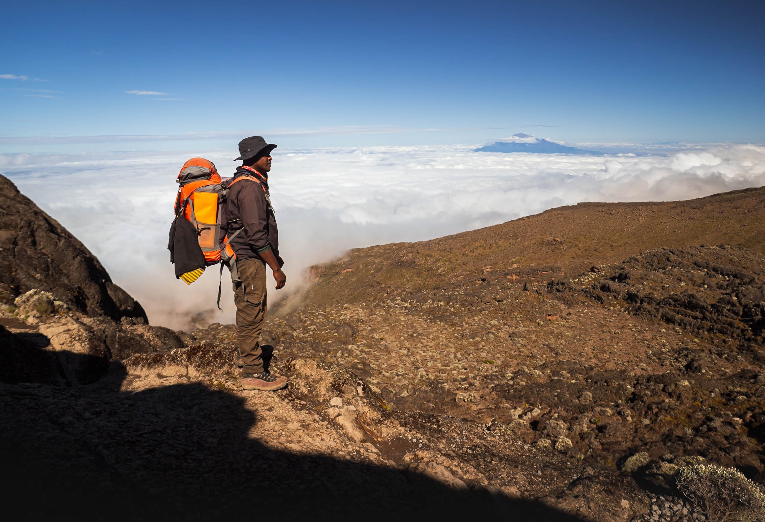
On the way back down and towards Shira 2 camp we passed some of the last signs of civilization on the mountain - a helicopter landing spot and a 4x4 road used for emergency evacuation and day-excursions to Cathedral peak. This time Paul posed for me knowingly, otherwise I mostly used him to create some human context in my photos without his knowledge - the orange backpack made a perfect colour contrast. You’ll see a lot more of it…


Day 4
Elevation gain : 939m
Camp altitude: 3900m
Total hiking distance: 15.29km
Total hiking hours: 6h 36min
Vegetation zone: Alpine Desert & Moorland
This was the first day where temperatures at night approached freezing, and my tent reflected that in the morning. It had cleared up again though, giving us another glimpse at the peak in the distance.
In the other direction, a few cloud layers got stuck in the mountain ranges, and we got a glimpse at Mount Meru, 70lkm to the west, standing at 4,566m tall.


But our path continued eastwards, and it would be the longest hiking day of the trip. That however, was a choice I made with Paul. After the enjoyable detour on Day 3, he proposed another opportunity to improve my acclimatization… luckily the team was still in a good mood, as we got closer and closer to the peak.


Lava Tower
We first had to reach a place called Lava Tower, at 4600m elevation. This rock formation is about 50m tall and over 150,000 years old, created as the result of a volcanic vent.
There’s a water source not far from the tower, so we stopped here for lunch with some other groups. To the right, we have Mr. Gangster, as he introduced himself - one of our porters and always happy when it was time for a meal.


It was a special lunch indeed! The backstory? In the van on our way to Lemosho gate, chef Christian asked me what my favorite food was. I told him that he’d struggle to cook that on the mountain, but answered “Pizza” anyway. Well, I underestimated him. He somehow managed to make something that was Pizza-adjacent with his little gas cooker, and whatever ingredients he brought with him for our 8 day journey! It was not bad at all, and he was rightfully proud.


After lunch, Paul and I left Lava Tower and followed a different path than everyone else: He decided it would be good to try and reach Arrow Camp, a site that once offered a different path to the summit, which closed a few years ago due to frequent rock slides. It meant another 300m ascent, reaching almost 5000m altitude. We made our way through the fine volcanic ash and sand that accumulated in this area. I’m not a geologist (very far from it sadly) but this part seemed to have interesting remnants of lava flow structures, and quite a few Obsidian rock fragments scattered around (some of which may or may not have made their way into my pocket).


From here, it is only another 6-7 hours to the peak, but it was hazardous route. The camp is named after the Arrow Glacier, itself named after its shaped, or rather, its past shape. The glacier has now all but disappeared, with only a few snowy remnants left. The entire ice cap of Kilimanjaro is rapidly shrinking, with over 80% lost in the 20th century alone.

Going up this far also meant we had to make it back down, as our next destination, Baranco Camp, was almost a full 1000m lower.
Altitude sickness is the most common reason people need to stop their hike and don’t reach the summit, and a slow ascent with the principle of “climb high, sleep low” is one of the best ways to avoid this issue.
The Giant Groundsel
But the way down brought us to an area I had been looking forward to see since I first researched the climb: a river valley that is home to Kilimanjaro’s most unique plants, called Dendrosenecio kilimanjari, a type of Giant Groundsel. Why are they special? Look at these photos…


Have you ever seen a tree or plant like this? Although they look like a cross between pineapple and cactus, they are members of the sunflower family (yes, really), and only grow in the mountain areas of east Africa, usually in the alpine zone and in proximity to water. One such area is Baranco Camp, our next stop.

While there are different species, this particular one is endemic to the mountain, and cannot be found anywhere else. Many grow to 5 meters and more, at only a few centimetres per year, meaning some of these plants are 100+ years old.
Once more, the crew set up my tent at a perfect spot, which was great, because I had some plans for the night! I was hoping for the fog and clouds to clear…


… so that I could get up around 4am after the moon had set, and capture these photos! My goal for the trip was to make it to the summit, but a second hope I had was to be able to have chance at photographing some Giant Groundsel under clear skies at night. Mission accomplished.


At this altitude, the most common animal you will encounter is the white-necked raven, often using the campsites to scout for sources of food, such as here at sunrise.
I did spot a four striped mouse around my tent as well one day, but it luckily didn’t find the way inside.

Day 5
Elevation gain : 430m
Camp altitude: 3995m
Total hiking distance: 6.50km
Total hiking hours: 3h 30min
Vegetation zone: Alpine Desert
Admittedly, I was not sure if I’d regret my nightly escapades in the freezing cold (I was only out for about 30min) the next morning, because one of the toughest parts of the climb laid ahead - the Baranco Wall, formed when Kilimanjaro went dormant around 150,000 years ago. In fact, it’s just a rather steep ridge of around 250m with a very narrow zig-zag path, that requires a single file approach - this makes it one of the busier spots on the mountain for sure.
The good news was that after you pass the wall, things would become a lot flatter, as the next camp was almost at the same altitude we started from. While feared, the ascent of the wall is ultimately not difficult or dangerous - there is some scrambling involved (long legs help), and a few very tight passages, but it is manageable. And your’e rewarded with some beautiful views of the Giant Groundsel gardens below - maybe the most special place here.


Beautiful views also await at the plateau on the top - you’re generally above the cloud layer at this point, so if it’s not foggy, Mount Meru will peak out above the clouds in the distance again.
At this altitude, you will find fewer and fewer plants in the area - the everlasting flowers on the left are an exception. These dry flowers can bloom all year round at up to 5000m.


All in all a relatively short day of less than 4h hiking, but it starts with a step ascent, and ends with one too. Not gaining much net altitude does feel a little frustrating after all the ups and downs, but in the end it all helps to prepare for the final summit (is that a metaphor for life?)

Karanga Camp
We arrived at our next destination in the early afternoon, and the rain hit hard shortly after. It cleared around evening, making for an interesting sunset atmosphere at camp.

Day 6
Elevation gain: 576m
Camp altitude: 4673m
Total hiking distance: 4.23km
Total hiking hours: 2h 45min
Vegetation zone: Alpine Desert
A rainbow woke us up this morning, which some would deem as a good omen - let me tell you, in terms of weather, it was not.

Today would take us to Barafu basecamp, from where you make the summit attempt just after midnight. It’s a relatively short day, which makes sense considering you will only sleep for a few hours until 11pm or so after you get to camp.
The peak is getting closer, and was still visible when we started…
… but that would change rapidly, as heavy winds of 50+ km/h started to blow down the mountain, while it began to rain at the same time. It’s generally relatively ok to deal with either: a windbreaker, or a poncho respectively, help. But the combination of your poncho getting blown in all kinds of directions, and the wind forcing the rain into every little opening of your clothing for 2 hours, makes for a less enjoyable experience. I took these two photos and then saved my camera from being drenched more than necessary.


All in all, this became the most miserable day of the journey, and the afternoon was spent trying to somehow use the gas burner fire to dry the most important pieces of clothing that would be needed again for the midnight summit attempt - no backups for gloves and shoes, and trying to reach the freezing peak with either of them in a wet state was a non-starter.

By the time dinner was on the agenda, the rain, which had temporarily turned into a snowy hail-like form, gradually faded, however the winds did not, and neither did the clouds on the summit. This was not looking promising - an ascent in heavy wind and low visibility was not really my preference, let alone the fact it would reduce any photographic opportunities at the peak and crater area to a minimum. At least the equipment was dry. Maybe things would look better after the four hours of sleep I was hoping to get before waking up and getting ready for the midnight start. As I went to bed, the tent was still shaking vigorously in the wind.

Day 7 - Summit Night & Descent
Elevation gain: 1190m
Camp altitude: 5895 peak to 3100m after summit
Total hiking distance: 10.58km to the peak + 10.81km down from basecamp
Total hiking hours: 9h 38min + 3h 14min
Vegetation zone: Arctic Zone to Moorland
As I got up after a few hours of not-so-deep sleep I heard the familiar rattling of the tent sheets: the wind hadn’t subsided much, but at least it was almost clear outside. The temperature had fallen and the air felt even colder due to the wind, so we expected -10C at the peak before sunrise. That is, if I’d make it to the summit! So far things had been very manageable, even approaching 5000m at Arrow camp was not am major issue: no symptoms of Altitude sickness, and my heart rate also barely scratched 150bpm.

But summit night is a little more tricky: starting at midnight and a total hike of almost 10h, up 1200m elevation in the first 7 hours taking you to the summit, it’s nonstop elevation gain, no level ground or downward slope to be seen. Oxygen levels at the summit would be less than half of what your body gets at sea level.
The moon was shining brightly though, making it almost possible to walk without headlamps - much more comfortable than during a really dark night I imagine.

Stella Point
We reached the first milestone at 5,756 meters, named after the first women who made it this far in 1925, about 45min before sunrise.
It’s not the end yet, but the last 1h or so before this point were the toughest - physically and mentally. It’s not a given to make it - during my ascent, I noticed a few people who had to give up here, and some that needed support to make it back down again.
It felt like the switchbacks on the way up would never end anymore, but once you see the golden glow in the distance and get to take some photos to distract yourself, everything becomes just a little more relaxed.
The path here leads to Gilman’s Point. Climbers coming from the northern routes pass it on their way to the summit, which lies in the opposite direction of the path, less than an hour walk away now.
To the Peak
I knew that the toughest part was done, but we still had to make it to the highest point - Uhuru Peak. Another 200m in altitude to go, but it is a gentle slope along the Kibo crater. You get beautiful views of the glaciers and the landscape below, and also a glimpse at the second highest peak of the mountain, the jagged walls of Mawenzi, in the distance.


Around half-way, the sun came up in the distance, illuminating the edges of the crater we were walking along. At this point, the wind had subsided, and the rays slowly warmed my fingers and cheeks. At the same time, you need to be careful as the sun gets intense very quickly, and much more so at this altitude than at lower levels.


The destination was close now - Uhuru peak is just behind the right rocky area in the image. On the left side, Mawenzi peak casts a triangular shadow into the distance.
The remaining smaller glaciers on the southern side of Kilimanjaro feature some incredible structures.


Peak Happiness!
Reaching Uhuru Peak - the Swahili word for “freedom. The name was adopted in 1961 when today’s Tanzania gained independence.
We took it slow for the last few hundred meters, enjoying the views - my final summit time was just before 7:00am. It was quiet at the peak: around 40,000 people attempt the summit each year, and the success rates are around 60-70% depending on the route. That makes around 100 people at the peak daily if you consider that most summits happen outside of rainy season - of course those are spread out over 4-5h in the morning. Just a few people were joining me at the peak during the 30 minutes we spent up here.
The first (recorded European) climb to this spot took place in 1889, while the fastest summit was in 2014 in a ridiculous time of 4h and 56min, which puts any feeling of accomplishment into perspective. Humans are crazy.
It’s easy to forget sometimes, but the panorama below shows most of the “flat” Kilimanjaro peak - it’s not just a small tip. The snowy hill to the left covers the Reusch Ash pit, a central hole of more than 100m in diameter that still emits faint sulfurous vapors. The last eruption of the volcano is estimated to have happened more than 350,000 years ago.

Visiting the pit takes another 4-5h from the peak, and in the current conditions would likely require snow shoes, so we did not make our way down into this area. Seeing it would be one of the reasons I might consider doing this climb again at some point.
To the very left of the panorama can see the northern ice fields, holding a cluster of large glaciers. It’s these ones you see in the famous “typical” Kilimanjaro photos from the northern side - as they say (and I feel I can confirm) “Tanzania has the mountain, but Kenya has the view”. It’s true that the perspective from Amboseli of the iconic flat top shape of the mountain with the white snowy tip is always the one used on any Kilimanjaro merchandise or marketing material.

Snow Patterns Close Up
On both the southern and northern side, the retreat of the ice field has been extreme, even satellite images from 20 years ago show a huge difference. It is estimated that by the middle of the century, the glaciers on the mountain will have completely disappeared.

The Way Down
We started our descent next, and it’s almost a little annoying that the feeling of triumph has to make way to the slightly irritating task of losing all this altitude again for the next 3 hours: your knees and ankles will not be happy at all.

Basecamp was in sight again, but we’d only spend an hour here to pack up, have some breakfast, and then continue our way down. The faster you descend, the less likely altitude sickness will catch up on you. There are two camps on the way down, and our goal was to make it all the way down to the lower one at 3100m.
While I survived the summit and celebrated with a tiny coke that I brought all the way up here, my shoes did not quite make it in the same cheerful state - but luckily still held up until the end.


If your physical state is closer to how my shoe looked like, then this is how they will bring you down to the nearest accessible helicopter landing spot - in the past, they used these carts to bring people all the way to the bottom.
There is also another variant that was used to bring down the bodies of people who passed away while trying to summit - luckily that has not happened in years, and with better emergency services, the mountain is now a very safe one.
The way down leads through an area that was recently affected by wildfires causes by human activities, leaving a huge trail of burnt trees behind. Fires have unfortunately been common in the National Park, with an incident happening almost every year.


We continued our descent through the ecosystems, finally arriving at Mweka camp near the beginning of the rain forest, at an altitude of 3100m. This was going to be our last night on the mountain!


Day 8
Total hiking distance: 9.48km
Total hiking hours: 3h 06min
Vegetation zone: Moorland & Montane Forest
Our last day led us through the beautiful rainforest zone again, this time on the southern slopes.


The forest here is incredibly beautiful, and worth a hike on its own if you don’t want to make it further up the mountain. It’s in this area where Africa’s tallest known tree was discovered in 2016, measuring over 80m and almost 500 years old.


The last bit of the path ends in a 4x4 road that is used for emergency purposes, and makes its way to Mweka Gate - the exit.

Arrived!
The final sign board at the exit, where I received my summit certificate and our van would pick us up and take us back to Moshi.

Time to Clean
It was time to clean. My shoes, my clothes, my bag, my camera, myself. 8 days without a shower take their toll.
Some Final Thoughts
On the last night in my tent, I wanted to write down what it was like, on the one hand to record it for a few people who asked me, and also to process it myself. So here goes, sorry for all the text, which is probably slightly repetitive. I’d summarise my experience in three areas:

The Emotional Part
A main concern I had was to be offline for so long, because I like to keep up with the world (for example, i subscribe to a few geopolitics and economics newsletters) and especially read a lot on technology (missed Apple’s WWDC for example). Secondly, I travel alone a lot, and (mainly) WhatsApp becomes a primary aspect of social interaction in those cases. This trip was also a solo expedition, and thus my connectivity-deprived socialising was limited to the interaction with my guide, and the occasional chats with the rest of the team helping one to conquer the mountain: learning some Swahili at dinner, or figuring out why one of them is called Gangster. Having a great team makes a difference!
I’m definitely not unhappy I didn’t do this trip in a group though: too many times did we pass teams that stopped because one person suffered one of an assortment of small problems, or encountered people being overly vocal or just constantly feeling the need to chit-chat or even play music while hiking, or witnessed discussions on what speed was the appropriate average for everyone. No thanks, I prefer my own rhythm, connection to the environment, and introvert downtime (I read Gambling Man during the trip, a biography about Masayoshi Son, the legendary SoftBank founder).
Having said all that, I’ve been offline for a few days before, but not 8 days. Funnily enough, knowing in advance and accepting it (and telling the people for whom it might matter) made it less of a factor - indeed so much so that I successfully resolved to ignore the unexpected appearance of a data connection in one or two spots, and the satellite WiFi they’re setting up in some of the lower camps (I don’t know if it works). FOMO - beaten! Getting back to reality of course requires some catching up regardless.
The Mental Part
The mental challenge to push yourself through the effort of climbing this mountain wasn’t - in my case at least - so much rooted in the difficulty of the hike. This was maybe because I felt physically quite able (see next section) and aside from summit day didn’t have to push extremely hard on any of the previous stages to make it to the destination for that portion of the climb.
Summit night (day 6/7) was different though indeed - it’s the anticipation of the highest altitude gain required on the trip (over 1200m), reaching almost 6000m where oxygen intake is half compared to sea level, the midnight start, the freezing temperature, and in my specific case, the intense wind and icey rain on the preceding afternoon, and not knowing whether those conditions would improve (or worsen) as you make your way up. Accepting all this, you’re just setting one foot in front of the other at this point, and finding some comfort in the fact that this routine takes you closer and closer to the goal. After over 4 hours of endless uphill hiking, you know the goal is close, but the remaining 1 hour up to the pre-summit milestone did require some mental grit to conquer - battling the endless switchbacks and non-stop elevation gain during that period was the most difficult moment of the entire journey.
Aside from the summit push, what was almost more taxing for me than the hikes was the general discomfort that comes with 8 days of sleeping in a tent on a mostly cold, often rainy and foggy, and very tall mountain: it’s less the absence of luxuries (like taking a shower, using a proper bathroom, sleeping in a normal bed, or picking what food you like that day), but more the fact that your stuff is effectively constantly wet or dirty (or worse, both): tent, shoes, socks, hat, toiletries, you name it, and there is hardly anything you can do to fix it or avoid it in the first place. I’m not a mountaineer by any stretch of the term, so maybe there are ways to manage it a little better than I did, but I found this almost more of an irritant on a daily basis than anything else. I brought a large-ish towel to help with some basic hygiene, and after a sweaty first day where I drenched it in a bit of water to clean, it literally stayed wet for the next 6 days. It makes you look forward to leave the tent behind and start walking.

The Physical Part
I consider myself reasonable fit, going to the (sometimes home-) gym two or three times a week, running 5 or 10km from time to time, and generally being active. I also walk a lot on most city travel for example, 15-20km per day are not unusual. Combined with the fact that Kilimanjaro isn’t considered a technically difficult climb, but rather a long strenuous hike, I felt confident, even though I didn’t specifically train for this adventure. An unknown was the altitude: I’ve been at 5000m + in the Himalayas on my snow leopard trip for example, but barely walked a few kilometres. Luckily, I didn’t have any signs of altitude sickness, and the long acclimatisation ups and downs of the 8-day Lemosho route help in this regard (as did our detours, I presume). We also didn’t look to finish the daily stretches quickly (pole pole!) and nevertheless were usually among the fastest third or so (especially compared to the groups) from what I observed. My heart rate never rose above 150 and usually stayed in the 120-140 zone 2 range during all hikes, with a decently low resting heart rate below 90, and blood oxygen never dropping below 90%. One of my struggles was surprisingly not breathing or legs, but the shoulders and back from carrying the weight of the backpack while mostly adopting a slightly hunched position as you ascend. In my case, that meant around 7-10kg, with 2L of water plus camera and two lenses making up the bulk of that.
The summit day was a slightly tougher story, I definitely felt exhausted once I fell back into my tent with various painful body parts, but it was still manageable. The way down wasn’t that much fun, perhaps unsurprisingly I arrived at the exit gate with a few blisters on my toes from spending 25km on a declining slope during the last 2 days. All in all, for someone of good health this is definitely doable. It’s not to be underestimated and you should have a good understanding of your fitness, the level of grit you can conjure, and how disciplined you are in the face of adversity. If you’ve never hiked at this altitude, you might need to push yourself beyond your known limits.
All in All…
Would I do this a second time? Probably not, but I can’t rule it out. I’m not a huge fan of hiking for hiking’s sake. If it comes with an interesting challenge (or more than one) and the opportunity to take some unique-ish photos, I’m always up for trying things though - and who knows, there are other interesting routes on Kilimanjaro, and the ash pit is also a place worth seeing... If this was a 3-4 day trip I might be more inclined, but it’s just a lot of overall sacrifice otherwise. So, I’m very happy to have stood on the top of Africa, but for now it will probably be the only time. There are other mountains to climb out there, literally and metaphorically.

