
The Mysteries of Easter Island
In the middle of the Pacific Ocean sits one of the most enigmatic places in the world (and one of the most remote!).

When I planned my first trip to South America, the primary goal was finding the very big cats of Chile and Brasil - but the former is also home to a rather surprising place, so different from the rest of the country that many people don’t know of its national belonging: Rapa Nui - or commonly known as the Easter Island. In the middle of the Pacific Ocean sits one of the most enigmatic places in the world (and one of the most remote). Although time was a little short and I ended up being able to spend just 2 days here, I couldn’t miss the opportunity.
Getting there…
…was half the battle. Or a little more than half. While Chile is already not the most centrally located and easily accessible country (admittedly that depends on where you start from), the Easter Island is on another level: Considered one of the most remote inhabited places in the world, it’s part of the Polynesian Triangle in Oceania. Its closest inhabited neighbor are the Pitcairn Islands (population: 40) at over 2000km away, while mainland Chile itself is 3500 km to the east. That’s a good 6h flight - of which there is one per day at the time of my travels in August 2024.

A Bumpy Ride
I was thinking about these facts as we made our third landing attempt, having aborted two due to very heavy winds, and circling for almost an hour over literal no-mans-land while we hoped for the storm to clear.
The pilots finally managed to land on the surprisingly long runway, which is one of the first peculiar things about this place: the island was originally considered as an abort site for Space Shuttle missions, and NASA extended the runway in the late 1980s. Nowadays that means a Boeing 787 can land on what is considered the most remote airport in the world, in a place with a population of less than 10,000 people.


The weather during my two days was a very mixed bag, as is common in this part of the world. The sea was rough, and the cloud cover only lightened for a few hours each day, and sadly less so (that is to say, not at all) during the night, which would turn out to be one of the disappointing aspects of this journey. More on that later.
Hanga Roa
As the rain cleared, I started with a short walk through the primary (and only) settlement on the island. Hanga Roa sits on the western side right next to the runway, and is home to the vast majority of the population, its only hospital, a football pitch, harbour, and quite a few restaurants, small hotels, and guest houses - tourism is a primary economic activity, supplemented by some farming and fishing, as well as the administrative aspects and a presence of the Chilean military.


A first Glimpse
Without meaning any disrespect, the city isn’t the reason to make the trip to the island for most visitors. But it does give you a glimpse of why most tourists arrive here: Just opposite the football pitch, you will find one of the almost 900 moais on the island.
This is probably the first encounter any tourist will have with them. Their story is long, controversial, full of unanswered questions, and of course adds to the mystique of the place…

As you walk just a few hundred meters further along the coast, a whole set of them awaits, situated on the typical “Ahu” giving many of the sites their names: a stone pedestal that serves as the altar for the moai placed on them. Despite its fame, the site only gets a little busy during sunset, otherwise you’ll find mostly stray dogs and horses around…

The Boat House - Hare Paenga
Close to the site is also a remnant of what the ancient accommodation looked here on the island: the so-called boat house, referring to the resemblence the finished houses have to a boat turned upside-down on land. Nowadays only the elliptical shape of the stone foundation is left.


I would visit these moais a few more times for some photos, as it was just a 20 minute walk from my hotel. The island is not very big - about 10 by 20 km in a triangle shape.
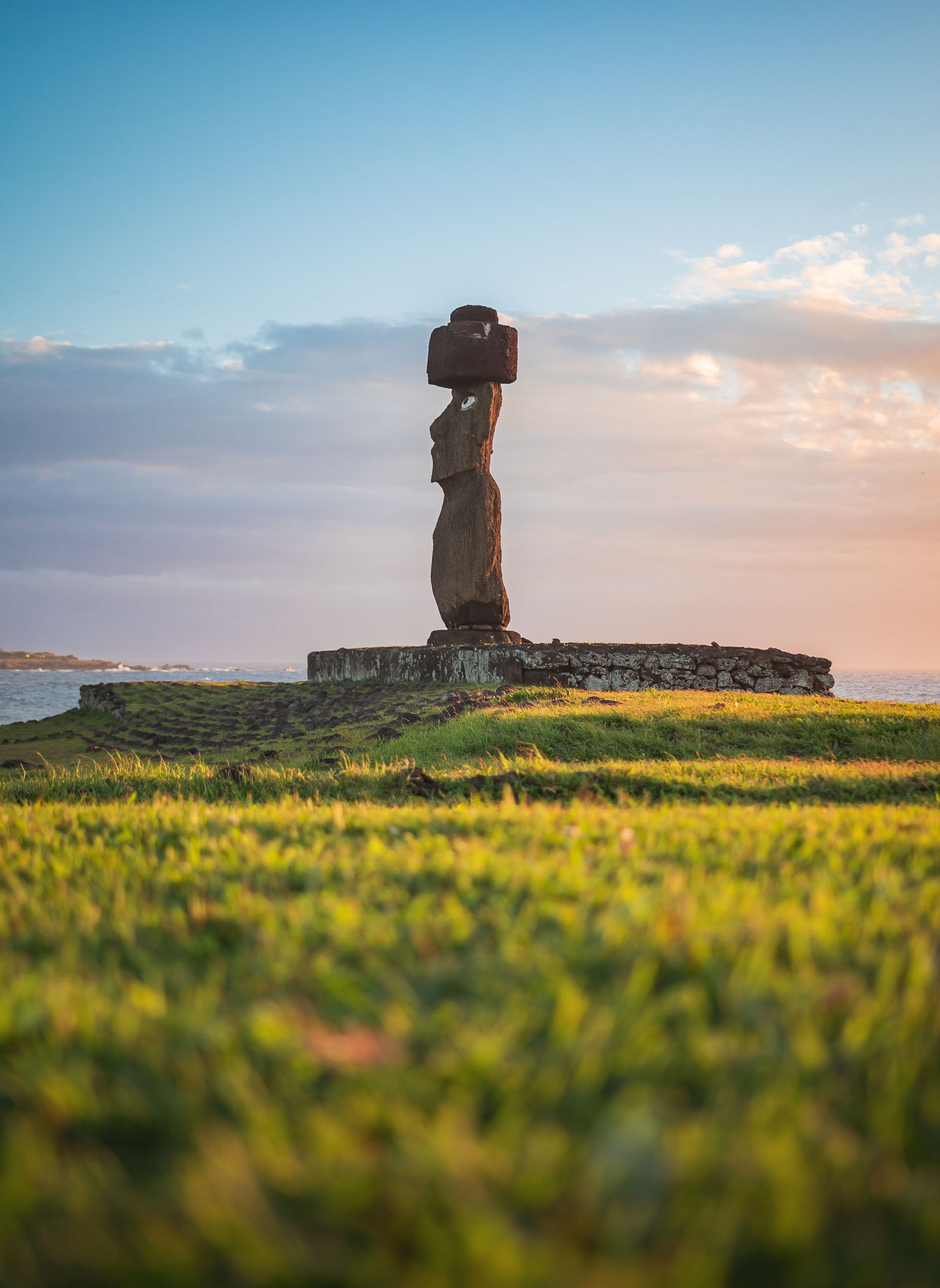
The collection here include this one called Ahu Ko Te Riku, which features the traditional hat like structure called Pukao, made from volcanic rock and added to the statues at a later stage, as well as the eyes made from coral stone, placed into the sockets and adorned with black obsidian or red scoria serving as pupils. This specific moai is the only completely restored one on the island with these features.

So many Questions?
It is at this stage (if not before) that you ask yourself what the point of these huge statues is, how they were made and moved to their resting places, and by whom and when! Some of those questions we shall try to answer in this blog…

The Moai
Although many of these questions have not been conclusively answered, there is plenty of evidence around. One such piece of evidence tells the tale of where the statues were produced: The quarry at Rano Raraku.


Almost all of the moai on the island were born on this site in the northern part of the islands, situated on the slope of an extinct volcano. The unfinished remnants of about 400 of them can still be found here, sometimes toppled over, partly buried, half finished in the rock, or simply abandoned during transport.

All the status are monolithic, and on average about 4 meters tall, weighing in excess of 10 tons. Some of them however are much bigger - the tallest standing at around 10 meters. Take a look at the above images to see how they scale against humans and horses.
The largest incomplete one seen here however is called Te Tokanga (the Giant), would be more than 20 meters tall, and weigh at least 270 tons, a multiple of the typical status scattered around the island.


It is often assumed that the moai are only “heads”, but in fact they represent full bodies - their heads are just oversized and the statues do not have very distinct legs. Some of them are in fact buried in the ground, with only the top third or so sticking out. Many moai feature carved designs, primarily on the back, and some of them were painted as well.

The quarry was active for several hundred years - it is said that most of the moai were built between 1100 and 1600 CE, with the peak somewhere in the middle of that period. The exact dates vary depending on the source. Moai carving was abandoned quite suddenly towards the end of this period, associated with the end of the Rapa Nui society that built them. The reasons for this remain controversial and unclear, ranging from the impact of contact with European explorers throughout the 18th century, to the disputed ecocide theory of self-induced collapse owing to resource imbalances.

Their Makers
But who made up this society? And did they have cats? These were the critical questions.
(Well, maybe the latter one was not so important, and cats only arrived at the island much later, but again showing why they are the truly dominant species of the globe).
The people erecting the moai were of Polynesian descent, arriving to the islands in ocean-going canoes after what must have been an incredible feat of navigation and endurance. When this happened seems difficult to say, and estimates range from around 400 to 1100 CE - even reliable sources do not fully agree on the dates, but the MET says it happened around 600 - 800 CE.
Ahu Tongariki
As you look east from the quarry, you will see their most famous work: a row of 15 moai standing on a huge stone platform, all facing inland, away from the sea. It is said that the reason for this placement is to watch over the villages and communities inland. The moai are considered to be representations of the Polynesians' ancestors, carrying their spiritual essence called “mana”.


As you get closer to the site, you can once again appreciate their size - the base plate alone is almost as tall as a human. Ahu Tongariki was the capital of one of the Rapa Nui clans on the eastern end of the island. Its claim to fame comes not just from its row of moai, but also the so-called “Traveling Moai” in front of it, for two reasons: it was shipped to Japan (and back) for an expo in Osaka in 1982, and later became the testbed for Thor Heyerdah, one of the most prominent researchers working on understanding Rapa Nui culture, who wanted to investigate how the moai were transported. Indeed, they made him “walk” for a few meters using ropes to generate a swinging motion. Whether this was truly the way they were transported for many kilometers remains disputed and alternative hypotheses add a kind of sled or cantilevers to move them along the ancient roads.


Celestial alignment
The site is positioned to provide perfect perpendicular alignment with our home star on the summer solstice around December 21st each year - for my vist in August, I needed a different perspective to get sun in frame (I visited both during sunrise and sunset). Sunrise here is also one of the few times where things get a little busy for an hour or two.


Toppled
Close the 15 main moai here lies a toppled one, with its facial structure somehow resembling the volcanic cliffs of Rano Raraku just behind. In fact, all the moai on the island were toppled over around the 17th and 18th century. Reasons are thought to be intertribal warfare to loss of faith in the ancestors' ability to protect them as Europeans arrived.

Restoration
As a result, all 50 or so standing moai (except some of the ones buried at the quarry) have actually been restored, mostly in the early second half of the 20th century. Ahu Tongariki suffered twice though - a tsunami toppled them over again in 1960 and swept the moai inland.
It was only in the 1990s that a team of Chilean and Japanese archaeologists restored them to their current state. The (few) photos floating around from the restoration efforts, one of them placed on a stone inscription at the site, feel quite surreal.

Luckily these 15 are now back on their (not-so-prominent) feet, including one with the red-colored Pukao top heat. These alone can weigh up to 10 tons, and it is believed a kind of ramp system helped the Rapa Nui to raise and balance them on the statues.

Ahu Tongariki from the sea, with the steep rim of the Rano Raraku caldera in the background. The quarry lies to the left side of the slope.
Beyond the Moai
We move on from our stone-headed friends for the moment, as there are a few other culturally interesting sites and beautiful landscapes to explore here. One of the former attractions is the so called Naval of the World - a rather peculiar stone structure on the northern coast of the island.

Natives
To get there, you need to make it past this man - an elderly Rapa Nui, a descendant of the indigenous Polynesians, which make up a bit more than half of the islands population today, with more having settled on mainland Chile after the island was annexed in the late 19th century.

Once the first guard is cleared, you need to bribe the second one with some cuddles - luckily my guide Yoyo has built some credit over the years.

Feline Tour
Indeed, it seems we qualified for dedicated guidance to find the Naval of the World!
As we look for it, we passed the remains of the tallest moai ever erected on the island at around 10 meters, with its Pukao on the left - almost 2m in height by itself.


The site is quite simple: the primary attraction is this central round stone, which is said to have been brought to the island specifically by the first king, Hotu Matua. One of its peculiar qualities is the impact it has on any compass in its vicinity, most probably due to its mineral content, although of course others may argue it’s the ephemeral spiritual power emitted from this piece of rock, the aforementioned “mana”.

Pu o Hiro
Just a little further down the road, a small unremarkable area with a simple fenced area is home to another rather interesting stone: this one posses some musical capabilities, and the locals would blow into one of the holes to create a trumpeting sound that served several purposes. A primary one was a call to aid fertility, and indeed, the stone features a few carvings that represent the female reproductive parts… other benefits seem to have been a trigger for rain, and for the fish to come closer to the coast.
The stone was actually on the move regularly during its original use, and its magic powers aided those victorious in clan battles.

A drive along one of the roads cutting across the islands brings you past one of its mounts, the small extinct volcano called Maunga Pu’i, with its beautiful textures and an almost fluffy looking covering of various bushes and grasses, with bright very green centre.

This place is home to a crazy yearly extreme sport event, where locals in traditional outfits use a kind of wooden sled to descend its slope from the rim in just a few seconds and dizzying speeds, with sometimes less than ideal outcomes. I did not get to observe this, but if you happen to be on the island whenever it takes place (dates seem to be around February during the Tapati festival, but it changes) don’t miss it.
Even if you tried, it’s hard to escape the ever present moai sites. They are spread all over the island, and although only a few feature standing statues, there are also a number of empty platforms (Ahu), and several toppled remnants dotted in the landscape.

Ahu Akivi
One more beautiful sight with several standing ones is the seven moai of Ahu Akivi, facing the sunset during the spring equinox and the only site not on the coast.

Ahu Nau Nau
Another is the beachfront collection at Ahu Nau Nau, where four moai still feature their characteristic hats.


The Moai under the Stars?
One of my goals for this trip was to try and capture the Milky Way rising above the moai. I liked the idea of connecting the mystery of their existence with the unknowns of our night sky. Unfortunately, the clouds had other plans. Despite two late-night outings (each after a long, exhausting day) I only got about ten minutes of clear skies through a small break in the clouds, leaving very little time to set up a proper composition.


It was not easy to arrange for access to the sites away from city lights at night (as they are in the National Park), get a guide to take me there at midnight, and skip pretty much all sleep for 3 days, only to then walk away with very little result after all the effort. I can’t deny that on my departure a certain frustration took over - that has settled a little by now, and turned into a motivation to go back and plan a few more nights on the island…

Rano Kau
On the south western tip of the island lies its largest volcanic crater. The southern edge of the caldera features a small dip where the lava once made its way into the ocean, the slope eroded by wind and waves into 300m tall cliffs.


The site is quite easy to reach, and part of the crater’s edge can be traversed on foot, allowing for views into the beautiful lagoon at the centre of the volcano. There are no permanent freshwater sources on the island, so the various volcanoes’ rainwater lakes played a central role in the past.

Rainwater Collection
It is also for this reason that in some locations around the island you can find these ancient stone bowls, which were used to gather freshwater at the time.
Orongo & the Birdman Cult
Just a bit further from the crater viewpoint lies the ceremonial village of Orongo. While the island’s culture is most well-known for the moai - rightly so probably - this aspect of the local rituals is less famous but rather intense. The cult emerged as the intrigue of the moai and their relevance as ancestral holdouts of hereditary power faded in the late 17th century, triggering a need to establish new patterns of power acquisition among the island's tribes, in the honor of the creator god Make Make.
Naturally, someone came up with the idea to satisfy this need by making contestants climb down the vertical cliffs at the edge of the island, brace the waves and sharks to swim to the furthest of the nearby islands, and wait for weeks for the arrival of the manutara bird, in order to collect its first eggs.
Then the warrior could announce his (yes, only men participated) success, but still had to make the way back with the intact egg to cement his clans rise to the top of the governance system for the following year, while he himself would spend most of it in a ritual confinement with very little to celebrate. Logical!
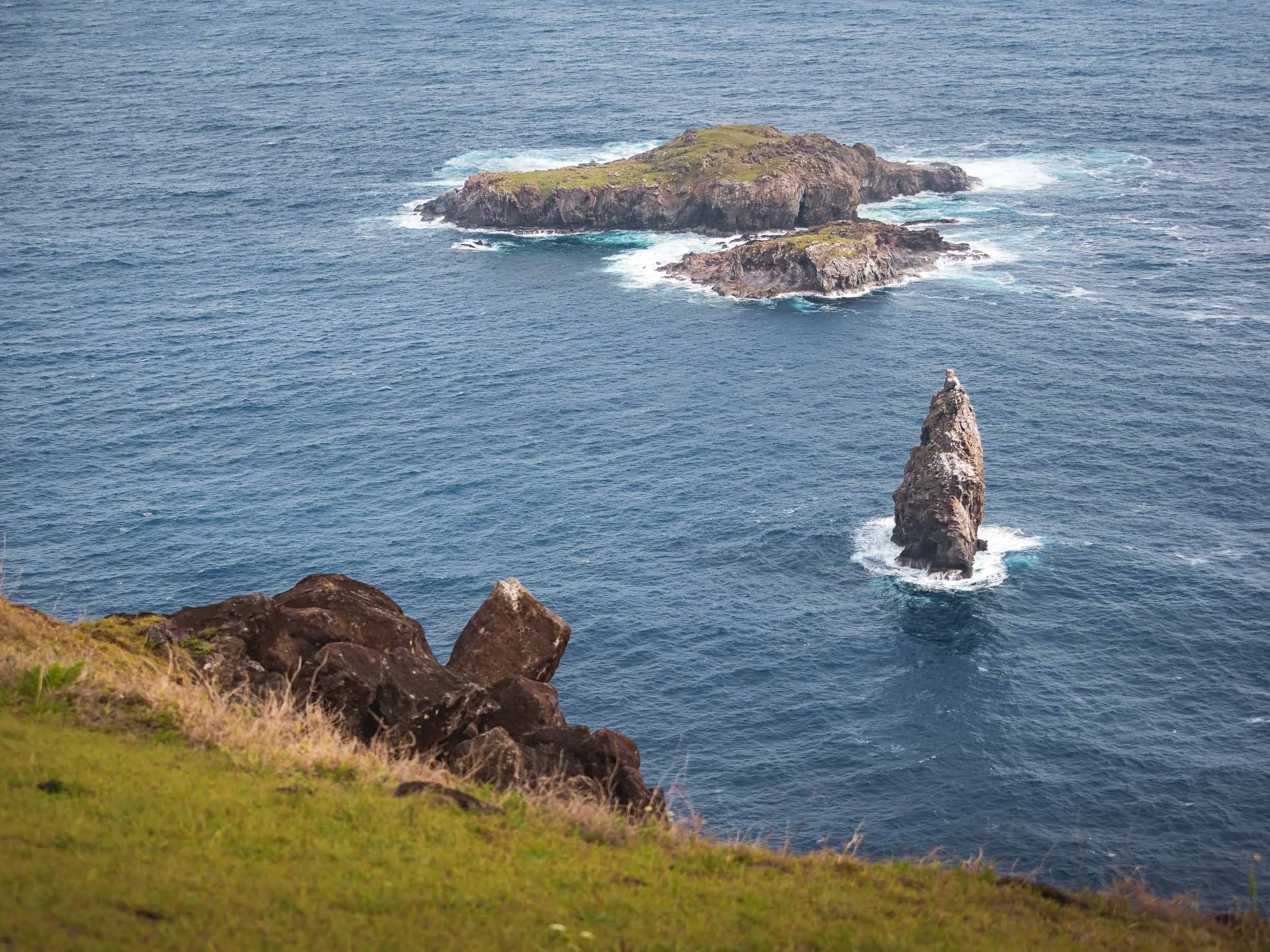
Having said that, the prominence of birds in the beliefs of the local is probably not surprising given that there were few other mammals or reptiles on the island. The islets to the south of Orongo can be seen here in the distance, the furthest of which the contestants had to reach to retrieve the highly sought after bird egg.


The village consists of 54 stone houses, the remnants of some are visible here to the left and right, including one of the entrances. It was only occupied during the spring time for the ceremony.

Dozens of large petroglyphs can be found here as well, many representing the Birdman cult.

Another example of these kind of petroglyph carvings is visible at the small outdoor museum on the road to the crater - you can see the bird-like drawings if you look closely.

Although often overlooked, there are actually beautiful petroglyphs at Ahu Tongariki as well, just a few dozen meters from the statues. Some of them also relating to the Birdman culture, while others show the face of the Make Make creator god and other important aspects of the Rapa Nui culture - even an image of a tuna (food is important)!


Religion
I spent my last morning with a final walk through Hanga Roa before my departure. The only Catholic church on Easter Island is one of the most prominent evidences of religious syncretism here - it features a mix of traditional mythology from the island, mixed with Christian symbolism. Even an effigy of Make-Make makes an appearance inside, and some of the mass proceedings mix both of the cultures.

The nearby cemetery includes graves that mix both spiritual approaches as well - I didn’t take more photos here out of respect, but there are graves with moai replicas, and some shaped like traditional canoes. Nevertheless, the arrival of Christian missionaries in the second half of the 19th century had a key influence on the diminishing role of the Rapa Nui culture.

Outside Impact
Aside from the religious influence, the arrival of Europeans unsurprisingly had a lot of other consequences for the island - starting with its name, given to it by the Dutch explorer Jacob Roggeveen, who was the first to set foot on the island in 1776 on Easter Sunday.
Spanish and British explorers arrived later, but the first serious negative consequences manifested themselves when Peruvian smugglers took over 1000 Rapa Nui as slaves, only to later return some of them diseases that wiped out a lot of the population. This continued when a French businessmen wanted to take over the island and use it as a sheep farm, forcing the local population to give up their land - in the end, only over 100 or so Rapa Nui were left in 1877.

Chilean Influence
Not long after this period, Chile moved to annex Rapa Nui, reportedly using misleading translations to secure agreement from the local population. This marked the beginning of a long phase of exploitation, during which the Rapa Nui were denied basic rights and restricted to living in the town of Hanga Roa. It wasn’t until 1966 that they were finally granted Chilean citizenship. Today, the island benefits from certain administrative privileges, and the designation of the Rapa Nui National Park as a UNESCO World Heritage Site in 1995 brought greater international attention and access to resources. Despite this progress, tensions still exist between the islanders’ desire for self-determination and the interests of the Chilean state - and indeed other countries: for example, one of the most famous moai called Hoa Hakananai'a with beautiful petroglyphs was taken from the island in 1886 and now sits in the British Museum, but there are regular voices for it to be returned to the island (sounds familiar?).
And that’s the end of my short time on the island - too short. Really keen to go back, explore more of the ancient volcanoes, a few more interesting natural and cultural sites, and most of all, get the chance to take some proper Milky Way photos with the moai 🗿✨ … one day!

A small notes on drone flying: I only flew mine twice, reasons being partly weather and wind, but primarily that most of the island is part of the Rapa Nui National Park, where flying is not allowed. I relied on my guide to decide when and where it would be ok to fly.
Subscribe to my newsletter to get notified and don’t miss out on more Wonders of the Globe.
Other Recent Posts:


Patagonia - Pumas & Peaks
The Chilean side of Patagonia is home to incredible landscapes and wildlife, and I spent a week here to document some of it during the winter months.

In August of 2024 I finally embarked on a trip to one of the last regions on earth I had not explored at all: South America. The first blog posts are in: Tales of the Atacama Desert and the Wildlife of the Pantanal. There is more to come, and this is the third post covering my trip to Brasil and Chile: The beautiful mountain landscapes of Patagonia, and one of the incredible animals that inhabits them…
From Puerto Natales to the Peaks
I arrived in the small city of Puerto Natales from Santiago (with a short stopover, there are barely direct flights in the winter time), but didn’t spend much time in town, other than a short photography walk to the shoreline with my great expedition guide Rodrigo and his wife, who were to become friends with a lot of laughs on the following days.

Puerto Natales was formally founded in 1911, but its history goes back further than that, with Spanish explorers making visits to the area in the early 16th century in search of the Strait of Magellan and indigenous people having occupied this remote part of the world. First human evidence dates back more than 10,000 years.

Two black-necked swans with the Hotel Costaustralis of Puerto Natales in the distance. My actual destination here was the Torres Del Paine National Park, around 100km to the north, a UNESCO World Heritage Site (one day I should make a list of which ones I’ve seen…).

Torres del Paine
As we drove towards the park, the namesake mountain range came into view, with a beautiful sunrise awaiting at the Amarga lagoon.

Calm Waters
While the weather is a little colder in the winter, it’s much less windy (reflections galore!) and the late sunrise and early sunset makes the life of a photographer a little more enjoyable…Here is the same spot a few days later in different conditions.
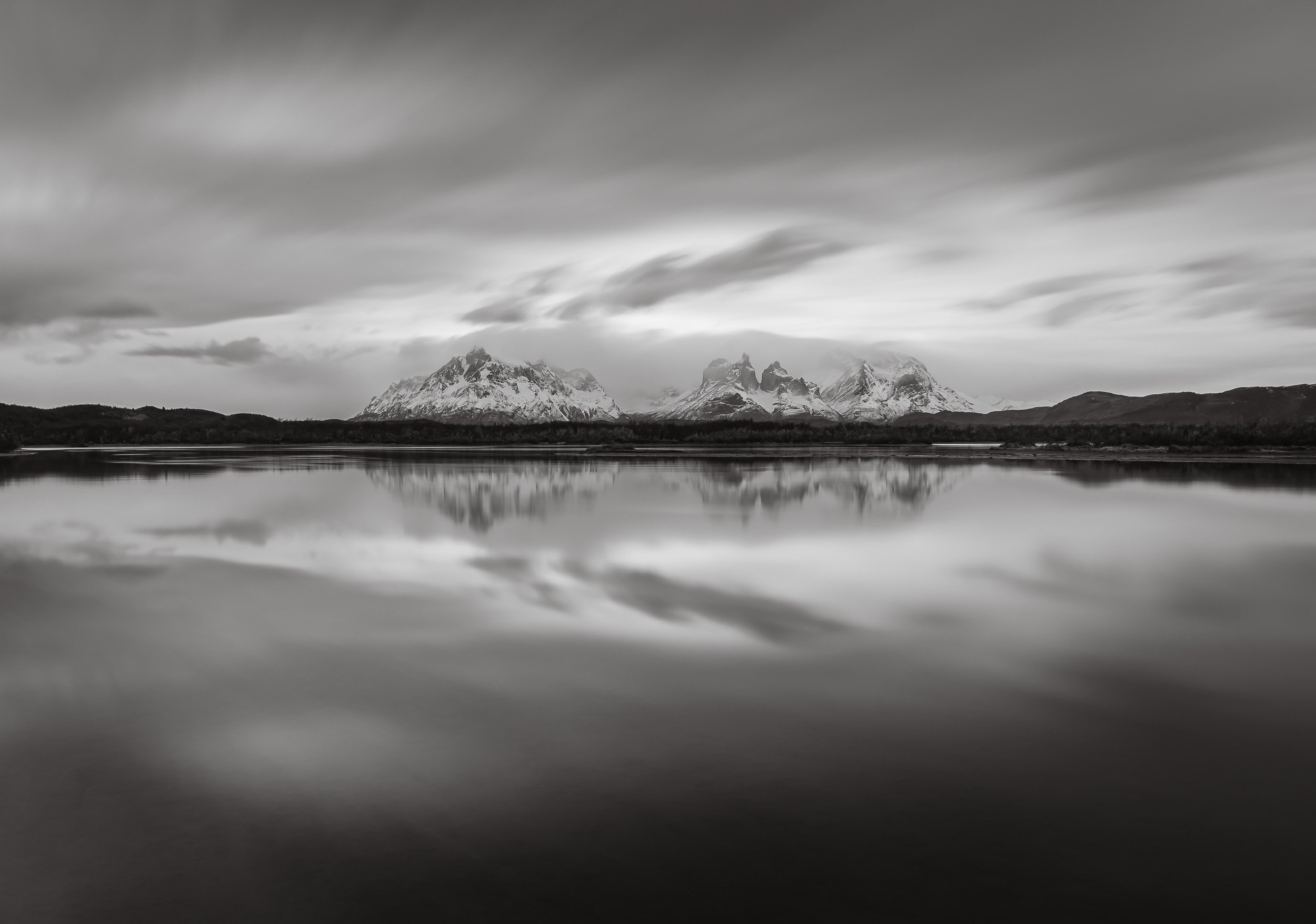
The Paine massive with its three individual peaks reaching almost 2500 meters above sea level are definitely its most iconic sight, and the many lakes and lagoons provide a beautiful foreground. The peaks make for endless compositions, and we spent quite a bit of time around the area.


The park is quite popular - but that still only means around 250,000 tourists a year. Most of those come during the summer months, making the trails, camping spots and roads a little more busy - in August when I visited other people and cars were a rare sight.


The same can’t be said for the guanacos, which were definitely quite a common encounter. Closely related to the llama (and their cousin the vicuñas, which you will see in my Atacama blog), they generally live in herds and don’t mind the high altitude - their blood has 4 times the number of red blood cells as humans.

To the north of the park entrance is this viewpoint of the Cascada Rio Paine, a small waterfall on the Rio Paine, the water of which finally makes it into the Lago del Toro.

We made our way through the park for the rest of the day, stopping at a few more spots, including the Salto Grande waterfall that comes from Lake Nordenskjöld away from the mountains. Can you spot my guide in the left photo?


The waterfall flows through a narrow canyon into Lago Pehoé. A bridge once crossed the lake here, but it collapsed during flooding from what I recall.

Konkashken Lodge
My sleeping place for the next few days was this little hut on the banks of the Serrano river, just outside the park boundaries - amazing place to stay with a very hospitable owner and his family.

The river landscape in this area is incredible, with a number of small lodges and hotels scattered around on the right, and the nearby confluence of the blue Serrano river and the discharged water of the grey glacier - the latter was still on the agenda for my last days here, keep reading!


Contrasts
A few dozen semi-wild horses live around the park, one of which was grazing in the muddy waters and spotted by my drone.
A sunrise like no other…

The next morning had what was probably the most beautiful sunrise I’ve ever seen in store - and I almost missed it. In fact, I did miss the early blue hour, because for what was maybe the first time in my traveling life I actually properly overslept, falling back asleep after waking up and getting ready a little too early…Luckily Rodrigo banged on my door and we were off to capture the colors lighting up the mountain peaks from a small lagoon.


Cerro Paine Grande mountain is the tallest mountain in the park at 2884m, and reflected back on us in a different colour every 5 minutes. It’s peak has only been climbed four times.


The Cuernos (Horns) getting kissed by the first light. No editing needed - sometimes nature increases its saturation without human help…take a look at this clip of a few more beautiful landscape moments taken with my drone (flying outside the perimeters of the park is permitted).

Not every morning was equally as colorful of course, so sometimes you need to add your own bit of human made colour. This little red bridge leads to a small island which houses the Hosteria Pehoe, a restaurant and refugio - it was still closed, just preparing for its summer season.

Icey Start
While overall bearable, Patagonian winter temperatures at night fall way below freezing.
A morning photo as the moon set, and an evening impression from one of the many little lagoons around the park, with a small lenticular cloud wrapping itself around a peak. Winter is the time for reflections here, with very little wind, which is rare in the summer, when there are warning signs on many of the roads and wind speeds commonly exceed 100 km/h.


Burnt Victims
A few parts of the park show the devastating effects of fires caused by tourists. Over the last decades, three incidents that destroyed over 150 sqkm each occurred, the last one in 2012.


While the dead trees that remain make for beautiful haunting photos, they are a reminder of how fragile the ecosystem is. Having said that, research has shown that naturally occurring fires have not been uncommon in the area for thousands of years.
Puma Quest
Although the landscapes were beautiful and not to be missed, my primary priority was to find and photograph another big cat for the collection (see here for some jaguar, snow leopard, and leopard photos, for example). This area is probably the world’s most famous to see the puma, often referred to as cougar and - aptly, given their appearance - mountain lion. Many documentaries by the BBC and National Geographic have been shot in and around the park, which would probably mean it’s good enough for me as well, just about…

On the lookout
Rodrigo scanning the mountain ranges for signs of the elusive cats.
We dedicated most of the mornings and late afternoons of the six days I spent in Patagonia to areas where pumas are frequently sighted, keeping an eye out for alert guanacos (or their complete absence, which is also a good indicator), prints, or other cars tracking them. Although there are estimated to be around 200 individuals in the territory, the first three days were not successful, and as the days dwindled, so did my hope for a good sighting.


While there was no pumas to be found for the moment, the guanacos served as decent alternative wildlife subjects.


Another common sight is the crested caraca, one of the large birds in the area, and they have gotten used to humans. In fact, the ones living near the Pehoe camping site, where we stopped a few times, are almost pets.


One more interesting species to observe when looking for pumas is the Andean condor, as they often follow the cats in the hope to scavenge on the remains of a kill, or even harass them to get their share. With a wingspan of over 3m and weighing 15kg, they are considered the largest bird of pray in the world and have an impressive lifespan of 70 years. The species is considered vulnerable today.


On the fourth afternoon, we once more made our way through one of the roads less travelled in and around the park, sleepily looking for puma clues after a nice lunch. But the sleepy vibe changed within a second, when suddenly, not one, or two, but three puma appeared just a hundred meters away from us as we crossed a small hill. Before we even realised what was happening, two of them dashed off over the hills into the distance. We suspected they were two younger brothers but could barely catch a glimpse of them. That left a large female gently walking on the slope besides the car, just 20 meters away.

The Sighting
At first she stalked and smelled the tracks of the two young puma that had just ran away, but didn’t seem particularly eager to chase after them.


A few moments of focused observation in the taller grass and bushes seemed enough to be sure the youngsters would not bother her again.

Crossing
Once she had made sure the intruders were nowhere to be seen, she changed direction, came down the slope and crossed the road, at which point we slowly scrambled backwards to give her space. Pumas in this area have gotten used to humans around, and don’t see them as a threat (or source of food) - that’s unlike anywhere else in the world, where this would be a very dangerous situation.
That’s not to say you should try and pet these large cats - keeping a distance, never cornering them, avoiding sudden movements and sounds, and observing their behaviour closely, are the key.

Notice the huge paws, the cut in her ear and slightly grumpy face, which gives her a very characteristic look - if anyone knows the name of this individual, please leave a comment!


She took a moment to chill in the short grass on the other side of the road, with the dramatic Patagonian mountain ranges in the distance, before making her way across the ridge, where it became impossible to follow her.

Queen
What an encounter! We probably spent almost 1h with her, observing different behaviors with no other soul in sight, in beautiful conditions.
Tip: One thing that I always find really useful when photographing unpredictable scenes like wildlife is to carry two camera bodies with different lenses with me - it’s hard to switch lenses in the field, and you risk missing the action. I used a previous Olympus flagship model for the wider angle photos here, and it is quite affordable nowadays, perfect for these situations.
Take a look at this video for a few clips of this amazing moment.

A few days later we did in fact have another Puma sighting in the very last light of the evening - this is the best photo I could get before it disappeared, putting the quality of the first sighting into perspective…

Puma Presence
We came back to the same area the next day, but she and her two companions were nowhere to be found. Instead, we opted for a small hike along the hills - probably crossing her territory. Guides are mandatory due to the presence of the cats, but the goal this time was to see evidence of humans, rather than cats.
There are a few places in and around the park with pre-historc rock art - this one is fairly easily to reach after about an hour of moderate hiking. These petroglyphs are from the ancient Aonikenk / Tehuelches culture, the nomadic tribes that once inhabited this area. The paintings on the cave ceiling in the left image are about 6500 years old.


Lago Grey & its Glacier

The quest for these big cats was also the reason landscapes and the longer hiking routes to or around the peaks (which can take 5-10 days) had to take a backseat - plus, the rising moon (and frequent clouds) didn’t make Milky Way photography an option during my visit, but I may be back for that…
Having said that, I moved to a different hotel for the last two nights, this time on the west side inside the park to explore its most famous glacier, feeling a little bit more relaxed after the successful Puma quest.

The calm shoreline of Lago Grey at sunrise, with the glacier just about visible as tiny bright blue spec in the distance on the left. In fact though it’s almost 6 kilometers wide, and the front face over 30 meters tall.

Iceberg Alert
It regularly calves, leaving large floating icebergs in the water, which gently make their way to the shores of the lake, where they slowly melt away.
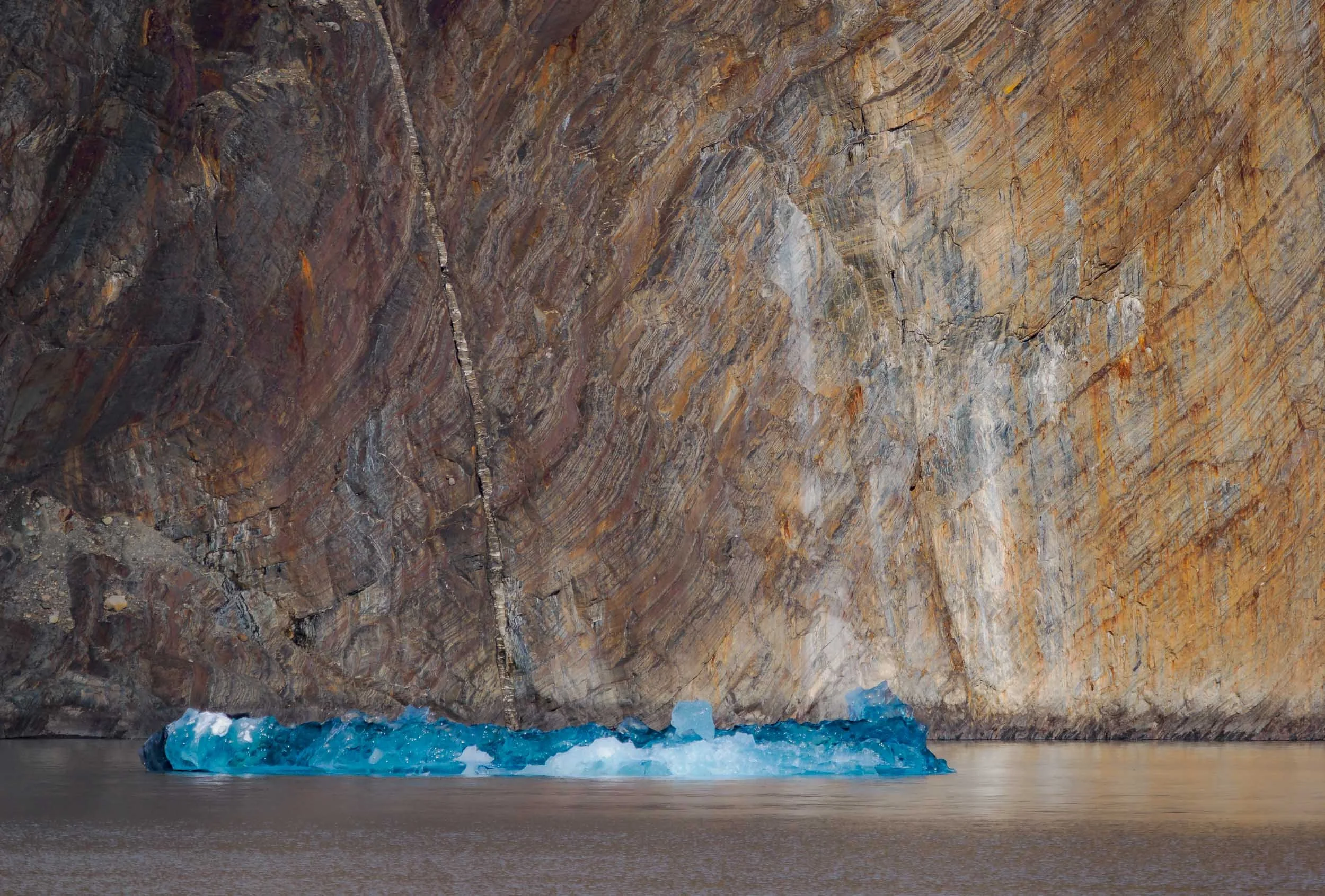
The goal was to get much closer though, taking a boat across the glacier lake for a better look at the details. I had the chance to explore glaciers in Alaska before, and while there are always similarities, every one is its own incredible feat of nature, with the heavily compressed blue ice slowly pushing its way down the slopes.


As the boat approaches, temperature drop noticeably and more and more ice appears on the lake, with the beautiful backdrop and earthy colors of the mountain ranges.

The glacier belongs to the Southern Patagonian Icefield - at almost 17,000 sqkm, it the world's second largest contiguous extrapolar ice field (the biggest being in Alaska).


Patagonia Aesthetics
Thev view towards the glacier from Hotel Lago Grey. Look closely to spot the boat that takes you close to the glacier.


One last morning view over the Cerro Paine Grande and its icey snowcapped mountaintop from a small waterfall near the (very expensive) Explora hotel. We saw a number of Puma prints here, and the accompanying smell also indicated they may have been here the night before, leaving their marks, but remaining unseen - to us anyway. But we had our moment.
And that was it from my trip to Patagonia, but I would say chances are high I might be back...
Disclaimer: This post contains a sponsored link from which I earn a small amount, but all the content absolutely represents my true opinion and is factual to the best of my knowledge.
Subscribe to my newsletter to get notified and don’t miss out on more Wonders of the Globe.
Other Recent Posts:

Tales of the Atacama Desert
Famous for its dry landscapes and amazing geological formation, this place is also a great spot to observe the night sky.

Chile was the first country I visited in South America, and I explored the capital Santiago, the remote Rapa Nui island, the landscapes of Patagonia (those blogs are saved for another day), and the stunning Atacama desert located in the northern part of the endless latitudinal expanse of the country. This blog covers the latter, so read on to see what the driest nonpolar desert in the world has in store.
Although the borders of the Atacama Desert aren’t unambiguously defined, it's save to say that it stretches over at least 1600km along the western coastline of Chile. That makes visiting all of it essentially impossible in a single trip, so I started with the common destination of San Pedro de Atacama, somewhat in the centre of much of it.


It’s a small town that today is the base for many tourists, but has been occupied for over 500 years at an oasis in the Puna de Atacama plateau around 2500m above sea level. The first people occupied this area as early as 10,000 BC.


Many of the mud brick walls here are remnants of the past, built with the local adobe earthy construction material, and can still be found all around the city, separating the individual plots of land and roads. The walls of the church above for instance date back to 1744, from the Spanish colonial period.


Into the Moon Valley
Despite the quaint beauty of the town, it’s the landscape that attracts most people to the Atacama region. One such landscape is the so-called Valle de la Luna, an area of interesting stone and sand structures with colorful patterns, and dry, salty, rock formations.


Fun fact: from what can be read online, a prototype for the ESA Mars rover was tested somewhere in this area. Easy to see why.

One of the many beautiful rock formations, but beware of the winds - we were close to being blown off this ledge a few times. Generally, it is said that summer (southern hemisphere) is the windier time, but we did get a couple of days of heavy gusts with some dust in the air. On the other hand, the temperature is more pleasant (albeit a little cold at night) and there are a lot less people around.

The Magic Bus 🚌 🪄
One of the man-made attractions in this area is this abandoned graffiti-decorated bus, that is said to have been left here when mining operations were abandoned decades ago.


We had it the entire evening to ourselves, as most of the excursions that make it to this area leave by late afternoon. The story goes the bus was a commuter vehicle for the workers, but I still can’t shake the feeling that it was left here for tourists 😄. I was assured by my awesome guide, friend, and fellow photographer Mauro (check him out if you want to visit Atacama!) it was not - which makes it all the more interesting.
Either way it makes for a very special kind of setting, and was going to be the spot to wait for darkness on the first day…


… so that we could get the Milky Way rising above it. The dark skies with no light pollution at a high elevation with almost no humidity make this part of the world one of the best stargazing regions on earth - it’s not a surprise some of the most important telescopes for scientific research, such as ALMA, have been set up here.


The area also has a few interesting eroded rock formations that provide more astrophotography opportunities.

We did not have a lot of time to enjoy the darkness though, as the moon rose shortly after. Unfortunately I could not time my trip differently, but moonlit landscapes have their own appeal. Can you spot my shadow?

Valle del Arcoiris 🌈
The other reason to not stay too long was that we had an early morning planned elsewhere - more specifically, the rainbow valley, where the moon was now setting…

This region is somewhat similar to the moon valley, but some parts of it feature different minerals causing incredibly colorful variations in the rock formations - see the layers below, with a close up on the right.


Living in the Shadows
People are often dismissive of barren landscapes and deserts, complaining about the lack of greenery - but this kind of scenery is equally beautiful to me.

Standing Out
It generally does not get very busy here, and our early morning arrival meant very few people around. Nevertheless, sometimes having one or the other person in the frame (not usually my speciality) can add a sense of scale to the landscapes: spot the couple in this photo!


The end of this small path leads to a canyon, with a few beautiful spots featuring deep red and purple rock colors.

Nature’s Shapes
The wind, sand, and occasional water (yes, even in the driest areas in the world flash floods happen) have done their job here and created beautiful rock formations all around.

Petroglyphs of Yerbas Buenas
Just outside the mars valley is this rather inconspicuous rock formation, which is filled with beautifully preserved Pre-Hispanic rock carvings.


The petroglyphs were created by the Atacameno people and are said to date back approximately 10,000 years. Many of them show llamas / alpacas (the domesticated versions of the vicuñas and guanacos you can find here - although the difference remains a little elusive to me), but of course I couldn’t help but focusing on the cat. An oddity is the presence of monkeys in some carvings, which never actually lived in this area.

As you make your way through the endless landscapes you can’t help notice the shrines to the side of the road, sometimes simple, sometimes quite elaborate. It’s easy to see that traffic deaths can be common here: large trucks, buses, vast distances, monotonous landscapes, straight two-lane roads with lots of overtaking are all part of the daily driving routine.

Cañon de Guatín
After a small rest break we were on our way to another different kind of landscape - the cactus canyon of Guatin.
Within a few hours drive around San Pedro de Atacama, the region offers very diverse types of geology and flora - the definition of “desert” is really much broader than what one’s imagination would prescribe.

The area stretches for a few kilometers on the slopes left and right of a small river, the Rio Puritama, which gradually cut its path into the rock for thousands of years.
As the sun sets, one side of the canyon remains illuminated and the light slowly fades away over the tall cacti, some of which are up to 100 years old and reach 7 meters in height.


Once again, we waited for the sun to set and the stars to shine to capture the different cactus species with the Milky Way rising.


Nightly Waterfall
A small waterfall in the canyon where nature strategically placed a cactus made for this nice composition.

Southern Trails
I had also set up another camera to capture some star trails with one of the cacti on the other side of the canyon, but we had another early start planned for the next morning, so 2 hours of trails is all I got for this image - the early start was worth it though…
Geysers Del Tatio
…because we went to the geysers of Tatio, around 2h drive to an elevation of almost 4500 metres, heading north and close to the Bolivian border. And of course wanted to be there for sunrise.

A short stop on the way at the Atacamenian village of Machuca, with less than 50 inhabitants and a small church that was established in the early 18th century overlooking the houses.

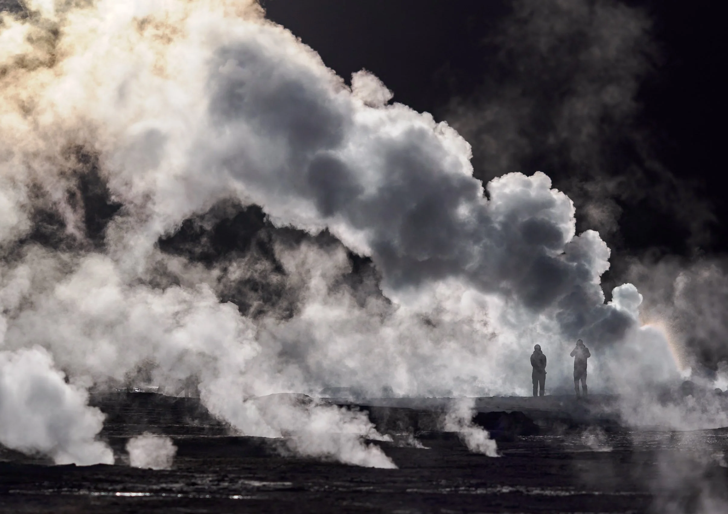
Smoky Fields
Shortly after, we started to see the rising puffs of smoke in the distance: The largest geyser field in the Southern Hemisphere, and the highest altitude field in the world. Spot the humans in the mist…


Extraterrestrial
El Tatio has been studied as an analogue for early Earth, and past life on Mars, owing to its extreme conditions where only the most robust of microorganisms could survive. Humans have been exploring the area for centuries - the old Inca trail from San Pedro de Atacama to Siloli crossed the geyser field.


The geothermal area covers around 30 square kilometres and is filled with hot springs and steaming vents - although only a smaller section is easily accessible by car or on foot.

Spectrum
Organic compounds and bacteria colour the sinter on the ground with orange-brown and greenish hues.


A vent and geyser cone - most of them only reach less than a meter in height, but occasionally fountains can grow to more than 10 meters.

Relics
Over most of the 1900s the site was considered for geothermal energy generation, but attempts were abandoned in the early 2000s over political and ecological controversy.
Landscapes
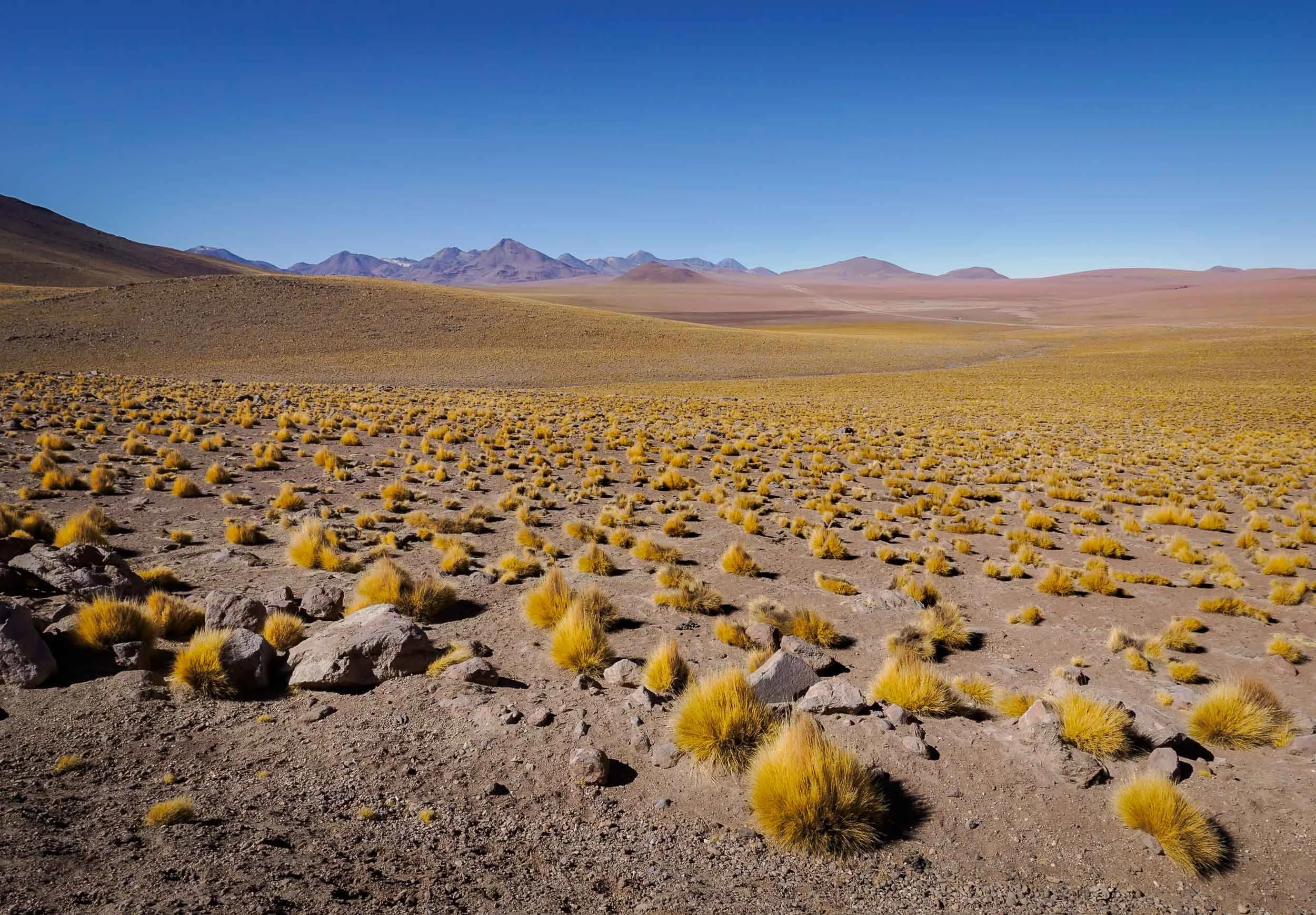
The region is part of a large volcanic complex with dozens of stratovolcanoes, many of which are still active, and some reach over 5000m in height.
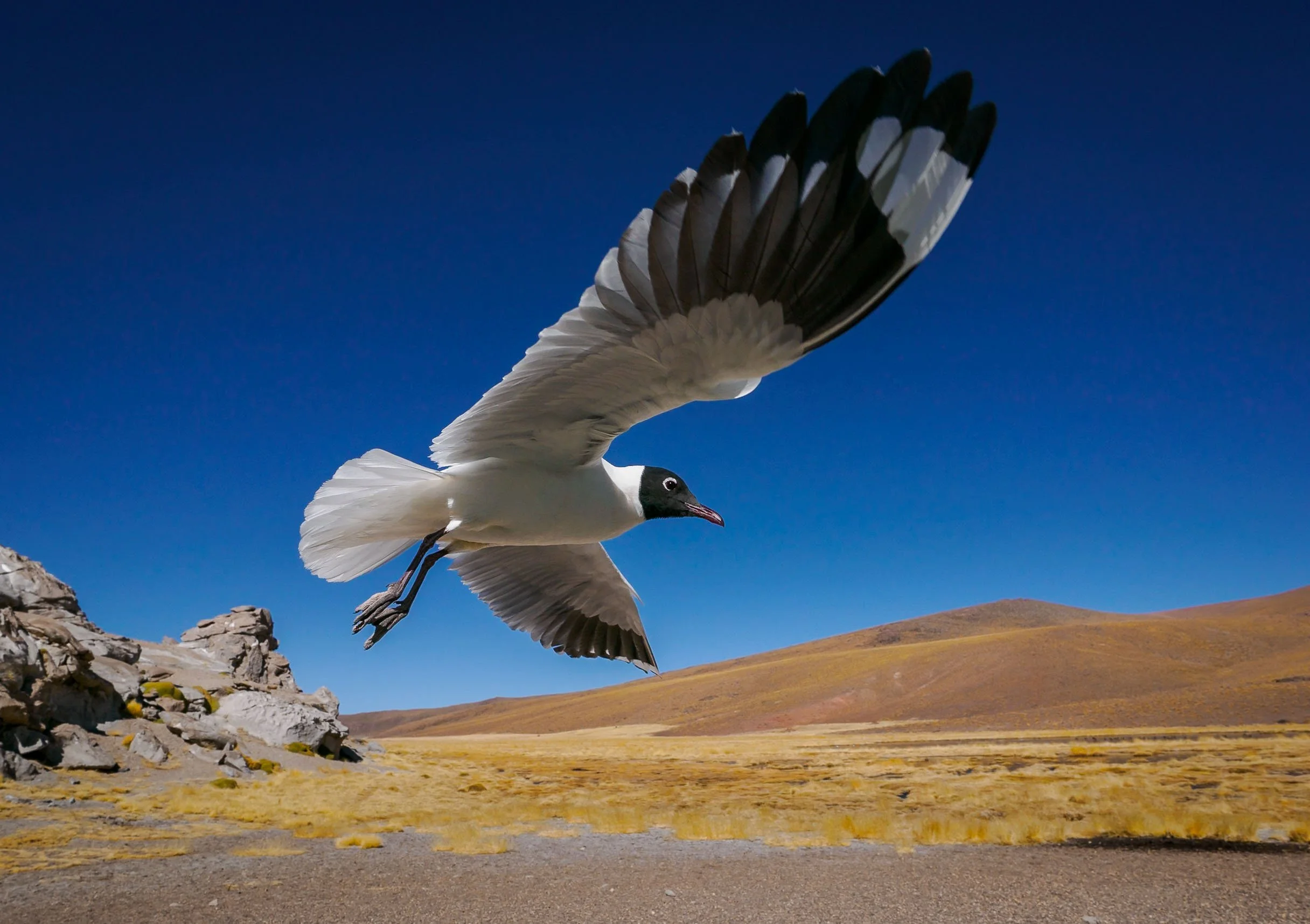
Despite the barren appearance and altitude, many vicuñas call this area home, and even puma can be spotted here occasionally. The Andean gull on the right has gotten used to tourists and came a little close during lunch break, making for a rather unique bird-in-flight photo.

The way back took us past the small lagoon of the Rio Putana, full of birdlife and with an abandoned mining operation just beside. Further down, a few spots offer beautiful views into the salt fields and the snowcapped Andean mountains.


Salar de Atacama 🦩
Our afternoon destination was one of several salt flats that are part of the Los Flamencos National Reserve.

The Chaxa lagoon is a beautiful landscape, with its main attraction being the large flocks of flamingos - depending on the season - enjoying the food in the shallow salty ponds, with the surrounding volcanoes casting their reflections in the water.


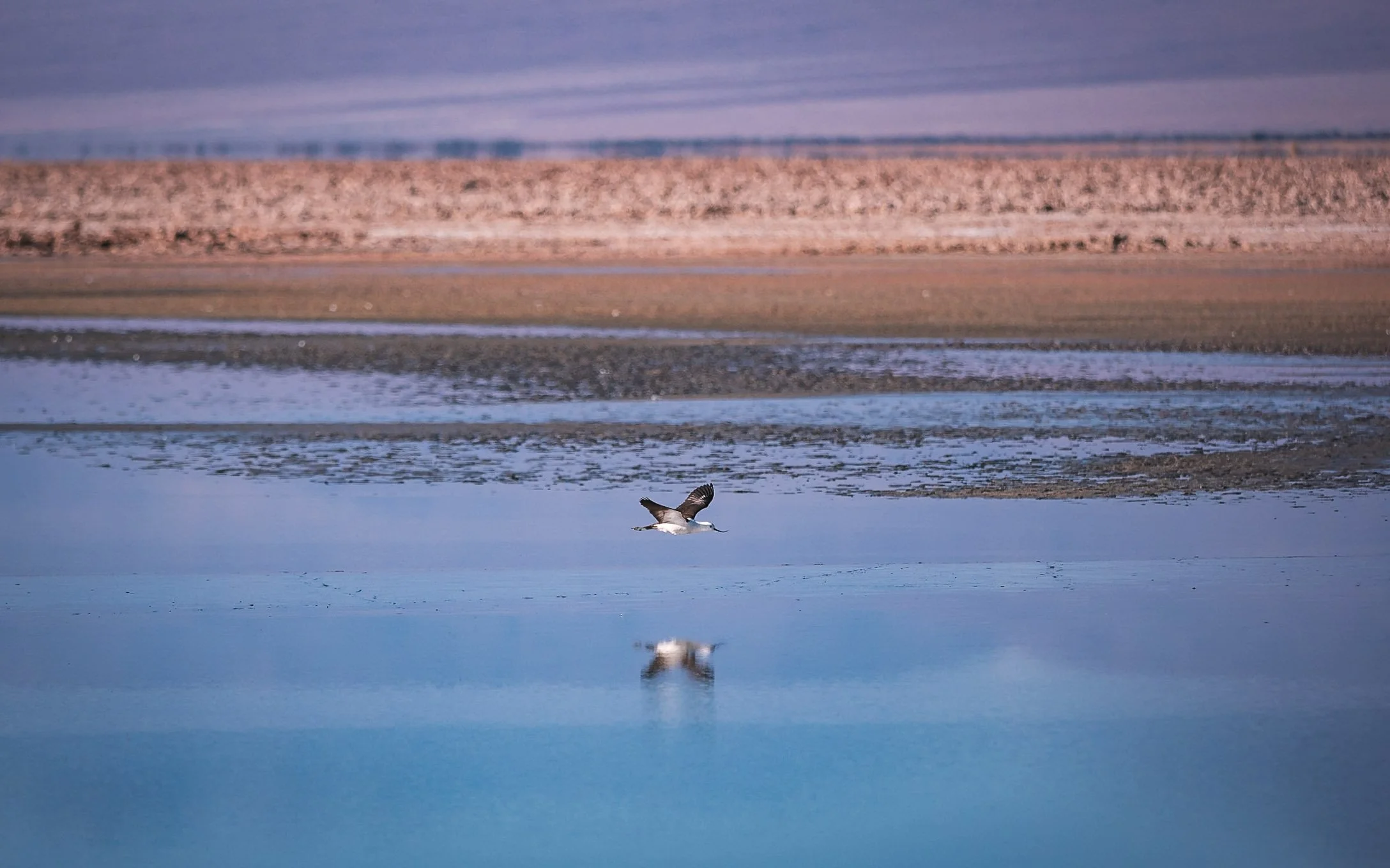
This ecosystem is home to rich birdlife, such as sandpipers or the Andean Avocet with its bent bill, but there are also mammals such as foxes and different types of rodents to be found here (not by me though…).


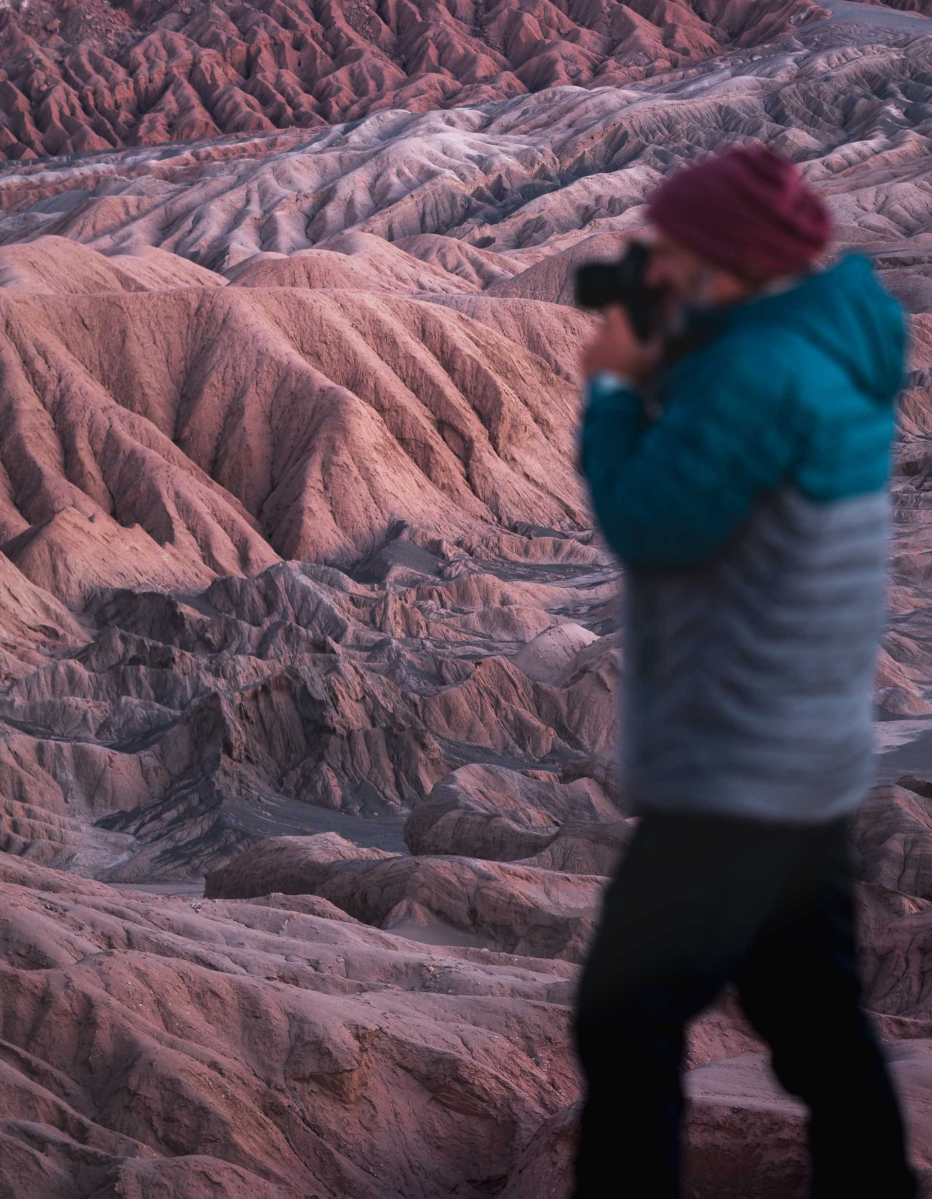
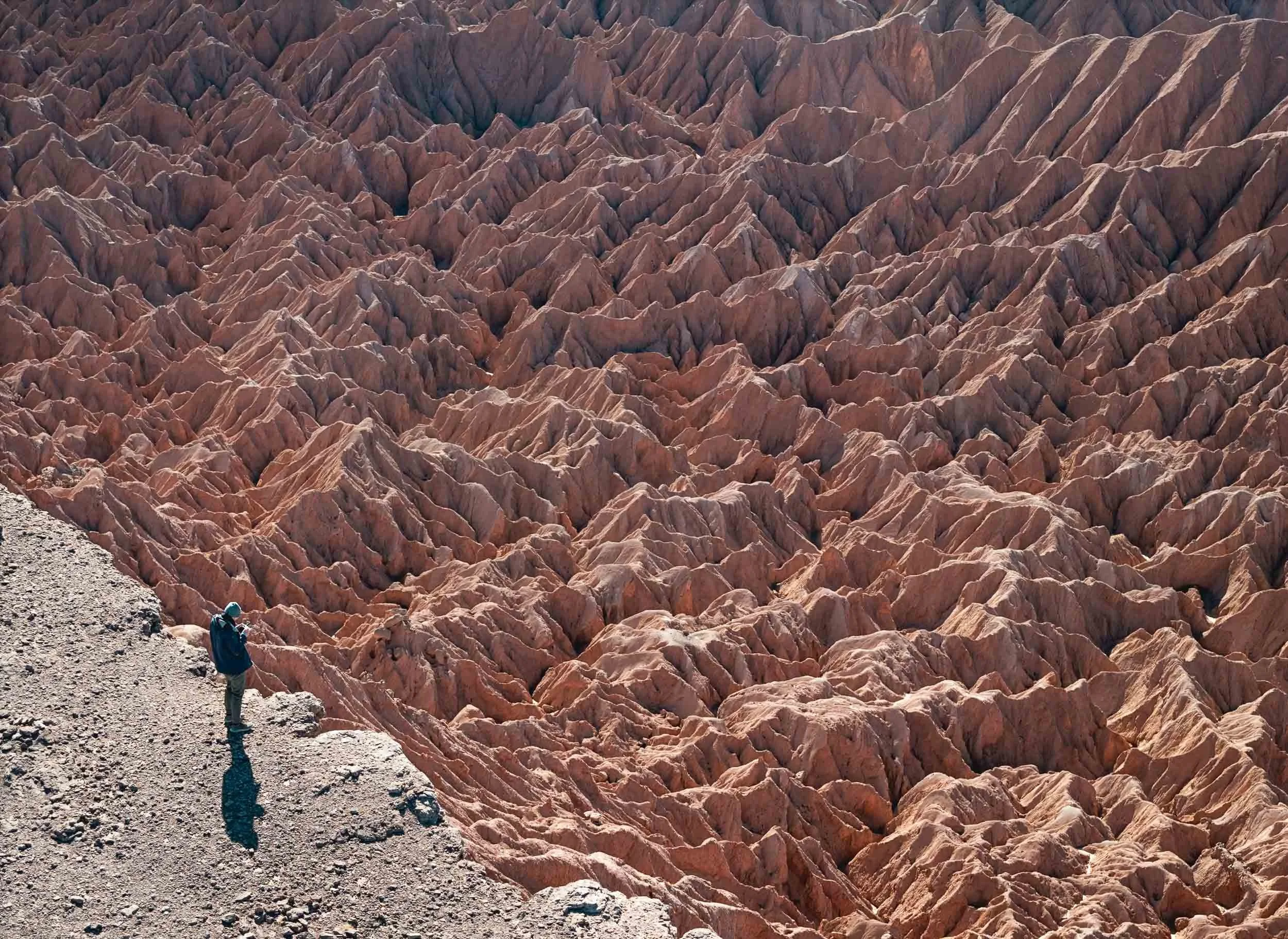
The Mars Valley
My last morning was spent at probably my favorite spot of the trip, the so-called Mars Valley, or Cornices. Some off-roading not too far from San Pedro leads to an elevated platform along the deep canyon ridges, with beautiful patterns and earthy tones. Take a look at the drone video below…
Orange and red hues start to glow over the landscape before sunrise.

First sun rays hitting the distant rock formations. The Atacama desert may be the oldest desert on earth, and has remained extremely arid for 150 million years.


Breakfast Spot
Not many better places for a nice start to the day.
The erosion has created some interesting patterns of jagged rocks in the valley along the steep canyon ridge - the upper left image below is a top down view.


Beautiful layers all around. This is one of the few places of this area of the Atacama desert with sand dunes.
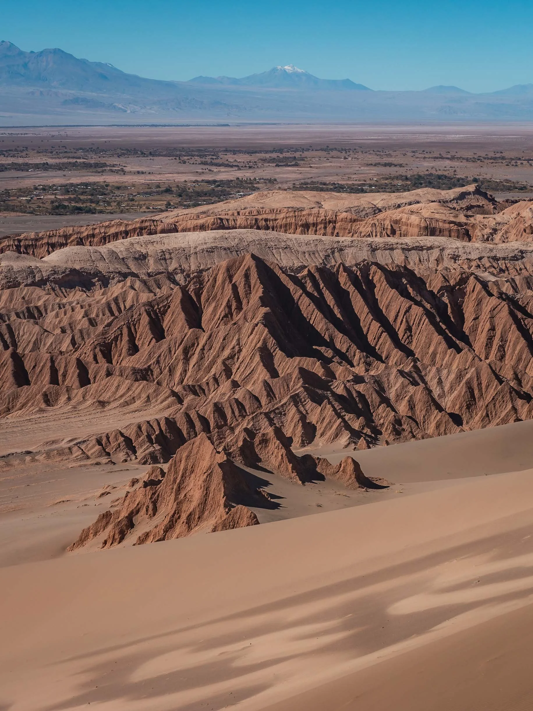


Panoramic aerial view on our way back. We didn’t encounter a single soul the entire morning.

A final look at the large wind farms around Calama, the main city in the northern area and home to some of the largest mining operations here, before I left the Atacama desert.
It feels like I barely scratched the surface of what can be explored here - and that’s because it’s true, there is a lot more to see in the region. I might need to come back… but for now I first have two more blogs from Chile in the backlog.